

About
Agremo is an AI-driven field analytics and precision agriculture platform designed for growers, agronomists, crop processors, drone service providers, and agricultural enterprises. By processing drone and satellite imagery through advanced machine learning models, Agremo converts raw aerial data into high-value agronomic intelligence. The platform offers four core modules: Crop Monitoring for season-long field health tracking; Field Trials for per-plot analysis supporting breeding and crop protection decisions; Plant Counting for accurate inventory management in plantations, nurseries, and forests; and Crop Insurance for AI-based damage detection and claim documentation. Key capabilities include AI-generated variable rate spraying maps that can reduce herbicide and fertilizer use by up to 75%, automated stand counts with germination rates and plant density metrics, weekly satellite-based plant health alerts, and high-resolution RGB and multispectral orthomosaic stitching with field boundary definition. Agremo supports a wide range of focus crops including corn, wheat, barley, rice, soybean, potato, rapeseed, sunflower, sugarcane, and more. It integrates directly with DJI Agriculture drones and provides recipe maps for precision variable-rate spraying. Reports and analysis outputs include CSV exports, SHP files, and population heat maps, making it easy to act on insights across the entire agronomy workflow.
Key Features
- AI Crop Monitoring: Use drone and satellite imagery to monitor crop health, detect weeds, analyze stand counts, and manage nutrients across the full growing season.
- Variable Rate Spraying Maps: Generate AI-powered variable rate application maps that can reduce herbicide and fertilizer usage by up to 75%, cutting costs while maximizing input efficiency.
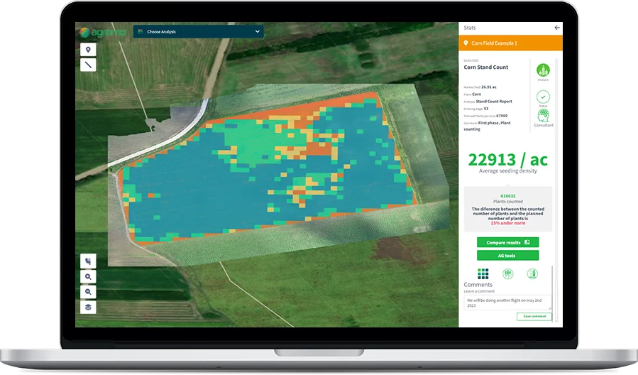
- Automated Plant Counting: Accurately count plants in fields, plantations, nurseries, or forests with AI-based point algorithms, population heat maps, and SHP file export.
- Field Trials Per-Plot Analytics: Analyze 14 agronomic traits per plot to support breeding programs, crop protection decisions, and hybrid selection with exportable CSV data.
- Crop Damage & Insurance Assessment: Detect lodging, green snap, and wildlife damage via drone AI analytics to support reliable insurance claims, with integrated weather alerts and history.
Use Cases
- A grower uses Agremo to perform AI stand counts after planting corn, identifying low-germination zones early and making targeted replanting decisions to protect yield potential.
- An agricultural cooperative uses variable rate spraying maps from Agremo to reduce herbicide application costs by up to 75% across thousands of acres managed for member farmers.
- A crop protection company runs field trials across dozens of plots, using Agremo's per-plot analytics and 14-trait CSV exports to evaluate new herbicide formulations and hybrid performance.
- An ag insurance assessor deploys drone flights over hail-damaged fields and uses Agremo's damage detection AI to generate documented reports supporting accurate and defensible insurance claims.
- A forestry professional uses Agremo's plant counting module to inventory a coniferous plantation, generating population heat maps and SHP files for reforestation planning and timber management.
Pros
- Significant Input Cost Savings: AI-generated spraying maps can reduce herbicide and fertilizer costs by up to 75%, delivering a strong ROI for growers and custom applicators.
- Wide Crop & Use Case Coverage: Supports 12+ major crops and serves diverse professionals — from growers and agronomists to insurance assessors and forestry professionals.
- DJI Drone Integration: Seamlessly integrates with DJI Agriculture drones to provide a turnkey solution from flight to precision spraying recipe maps.
- Actionable Reports & Exports: Delivers ready-to-use outputs including orthomosaic maps, CSV exports, SHP files, and heat maps that fit directly into existing agronomic workflows.
Cons
- High Entry Price: Plans start at $1,950/year, which may be a barrier for small-scale individual farmers or those just beginning to adopt precision agriculture.
- Requires Drone Equipment: Full platform value depends on access to compatible drones, adding hardware costs and operational complexity for new users.
- Custom Pricing for Insurance Module: Crop insurance and damage detection pricing is not publicly listed, making it harder to evaluate total cost upfront for that use case.
Frequently Asked Questions
What types of drones does Agremo support?
Agremo integrates with DJI Agriculture drones and is compatible with standard drone imagery inputs. The platform processes both RGB and multispectral imagery to generate analytics and spraying maps.
How does Agremo generate spraying maps?
Agremo uses AI to analyze drone imagery and identify areas with varying levels of weed pressure or nutrient deficiency. It then generates variable rate application (VRA) recipe maps that can be loaded directly into compatible spraying drones or machinery.
Is there a free trial available?
Yes, Agremo offers a free trial with no credit card required. You can request a free demo to explore the platform's capabilities before committing to a paid plan.
Which crops does Agremo support?
Agremo supports a wide range of field crops including corn, wheat, barley, rice, soybean, potato, rapeseed, sunflower, sugarcane, sugar beet, cotton, tobacco, and more, as well as forestry applications for coniferous forests.
How is Agremo used for crop insurance?
Agremo's crop insurance module uses drone-based AI analytics to detect and document crop damage such as lodging, green snap, and wildlife damage. It provides accurate, verifiable reports to support insurance claims, along with weather alerts and plant count data.