
E
About
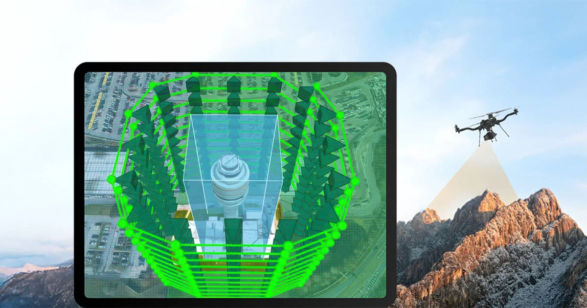
ArcGIS Flight is Esri's dedicated mobile application for professional drone operations, designed to bring precision, safety, and geospatial intelligence to every flight mission. Pilots can plan automated, repeatable flights using task-specific flight modes—from wide-area surveys to vertical structure inspections—while leveraging real-time terrain data and imported GIS layers for enhanced situational awareness. The app's Terrain Follow feature automatically adjusts drone altitude to maintain consistent height above the ground, increasing both safety and data quality. Advanced 3D mission planning tools allow pilots to visualize flight paths, optimize overlap and coverage, and account for elevation changes before takeoff. ArcGIS Flight supports geospatial video capture, tagging each video frame with precise location and orientation metadata for downstream analysis in ArcGIS. For regulatory compliance, US users benefit from direct LAANC integration with Airspace Link for real-time FAA airspace authorization, while international users can import airspace boundary layers from GIS sources. The app is the field-capture cornerstone of Esri's broader drone mapping ecosystem. Data flows directly from ArcGIS Flight into processing and analysis tools like Site Scan for ArcGIS, ArcGIS Drone2Map, and ArcGIS Reality for ArcGIS Pro, enabling organizations to turn raw drone imagery into actionable geospatial insights. It is best suited for GIS professionals, surveyors, infrastructure inspectors, and enterprise drone program managers operating within the Esri platform.
Key Features
- Automated Mission Planning: Create repeatable, automated drone flight plans with intelligent controls and task-specific flight modes optimized for surveys, inspections, and mapping workflows.
- 3D Mission Visualization & Terrain Follow: Visualize flight paths in full 3D and automatically adjust drone altitude to maintain consistent height above terrain for safer, higher-accuracy missions.
- Geospatial Video Capture: Record drone footage enriched with sensor location and orientation metadata, enabling each video frame to be mapped and analyzed within ArcGIS.
- Airspace Compliance Tools: Integrate with Airspace Link's LAANC system for real-time FAA authorization in the US, or import custom airspace boundary layers for compliance outside the US.
- End-to-End ArcGIS Integration: Seamlessly share captured data with ArcGIS Online, ArcGIS Pro, Site Scan for ArcGIS, and ArcGIS Drone2Map for streamlined processing and analysis.
Use Cases
- Conducting large-scale aerial surveys for topographic mapping, land management, and environmental monitoring by GIS professionals.
- Performing infrastructure inspections of bridges, towers, pipelines, and utility assets using vertical flight modes and repeatable automated plans.
- Creating high-accuracy 3D models and reality meshes of construction sites, urban areas, or archaeological sites for analysis in ArcGIS Pro.
- Monitoring change over time on construction sites, agricultural fields, or disaster-affected areas by re-flying identical automated missions.
- Capturing geospatially enriched video for situational awareness during emergency response or public safety operations, with footage directly usable in ArcGIS maps.
Pros
- Deep ArcGIS Ecosystem Integration: Smooth data flow between ArcGIS Flight and the full suite of Esri products eliminates manual data transfer and accelerates the path from capture to actionable insights.
- Advanced Safety & Compliance Features: Terrain Follow, 3D visualization, and built-in LAANC authorization significantly reduce operational risk and help pilots meet regulatory requirements with minimal effort.
- Repeatable, Automated Missions: Automated flight plans with consistent settings reduce human error and allow teams to re-fly the same mission for change detection and monitoring use cases.
- Geospatially Enriched Data Output: Every image and video frame is tagged with precise geospatial metadata, making the captured data immediately useful for GIS analysis without additional processing steps.
Cons
- Requires Esri Ecosystem Investment: Full functionality—especially advanced processing and analysis—requires purchasing additional Esri products like Site Scan for ArcGIS or ArcGIS Drone2Map, increasing total cost.
- LAANC Compliance Limited to the US: Automated airspace authorization via LAANC is only available for US-based operations; international users must manually import airspace boundary data for compliance.
- Not a Standalone Solution: ArcGIS Flight is designed as part of a broader Esri workflow, making it less suitable for operators who need a self-contained drone management platform.
Frequently Asked Questions
What is ArcGIS Flight?
ArcGIS Flight is a mobile application developed by Esri for drone flight planning, mission automation, and geospatial data capture. It is part of Esri's end-to-end drone mapping system and integrates directly with ArcGIS products for seamless data processing and analysis.
What is the Terrain Follow feature?
Terrain Follow is an automated altitude management feature that continuously adjusts the drone's flight height to maintain a consistent distance above the ground surface, even over uneven terrain. This improves mission safety and ensures uniform image overlap for accurate mapping.
Does ArcGIS Flight support airspace compliance?
Yes. In the United States, ArcGIS Flight integrates with Airspace Link's LAANC system to provide real-time airspace intelligence and FAA authorization. Outside the US, pilots can import airspace boundary layers from GIS sources to visualize and plan compliant missions.
How does ArcGIS Flight integrate with other ArcGIS products?
ArcGIS Flight connects directly with ArcGIS Online, ArcGIS Pro, Site Scan for ArcGIS, ArcGIS Drone2Map, and ArcGIS Reality for ArcGIS Pro. Imagery and geospatial video captured in the field can be synced and shared across these platforms for processing, analysis, and visualization.
What types of drone missions does ArcGIS Flight support?
ArcGIS Flight supports a range of mission types including wide-area photogrammetric surveys, vertical structure inspections, and geospatial video capture. Tailored flight modes and intelligent automation help pilots optimize settings for each specific mission type.