

About
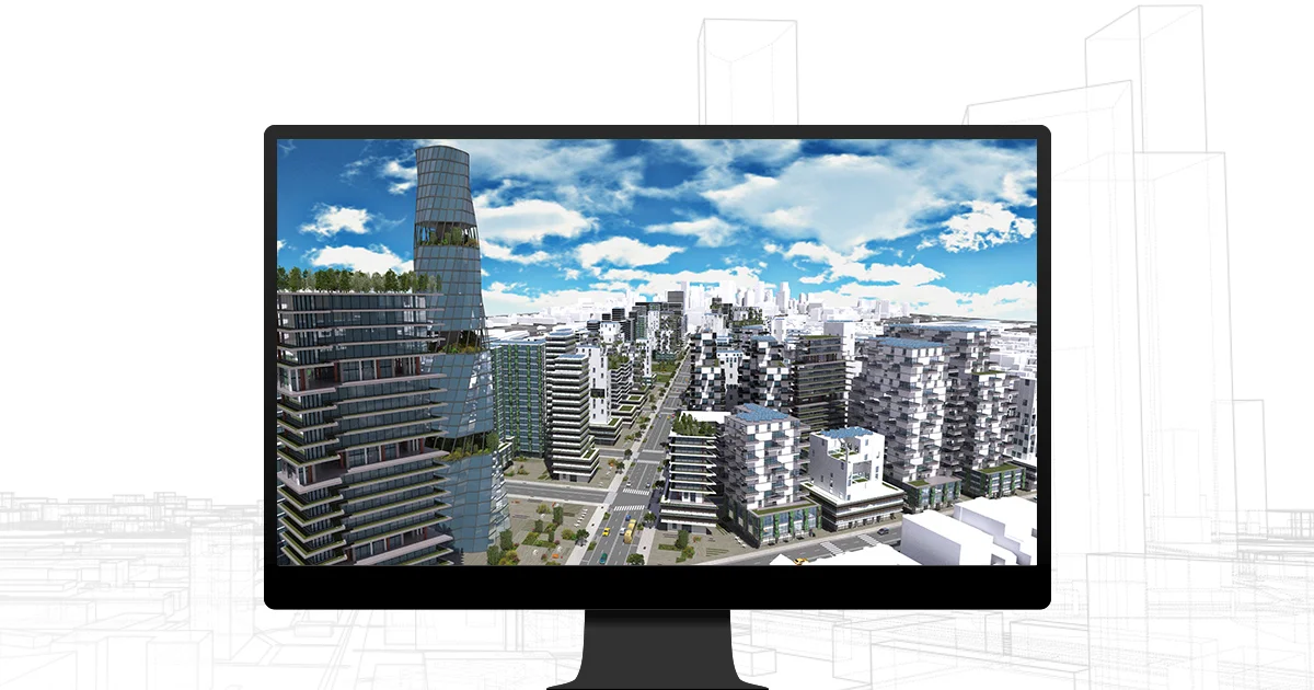
ArcGIS CityEngine by Esri is a powerful procedural 3D city generator purpose-built for urban design, city planning, architecture, and immersive visualization workflows. At its core, CityEngine allows users to create highly detailed, scalable 3D urban models by consuming real-world geographic information system (GIS) data—including shapefiles, geodatabases, CAD, and BIM files—or by designing entirely synthetic environments from scratch. The tool excels at rapid iteration: users can adjust architectural styles, floor plans, sizes, textures, and zoning parameters on-the-fly without rebuilding models from the ground up. This makes it invaluable for testing multiple urban development scenarios and presenting design alternatives to stakeholders. CityEngine integrates seamlessly with the ArcGIS platform, enabling deeper collaboration through ArcGIS Urban and access to basemap and terrain data via the Get Map Data function. For immersive output, the tool connects to industry-leading game engines (such as Unreal Engine and Unity) via free Esri-provided plug-ins, enabling the creation of hyper-realistic VR/AR experiences and interactive simulations. Ideal for urban designers, city planners, architects, 3D artists, and GIS professionals, CityEngine is used globally by organizations ranging from architecture firms like Foster + Partners to municipal governments seeking smarter, data-driven planning workflows.
Key Features
- Procedural City Generation: Automatically generate detailed 3D urban models from rule-based procedural algorithms, enabling fast creation of entire city environments at any scale.
- Real-World GIS Data Integration: Import public or private basemap and terrain data, shapefiles, geodatabases, CAD, and BIM files to ground designs in real geographic context.
- Multi-Scenario Design Iteration: Procedurally generate multiple design alternatives based on different zoning, architectural, or development requirements and share them with stakeholders for feedback.
- Game Engine & VR/AR Export: Connect CityEngine models to Unreal Engine, Unity, and other leading game engines via free Esri plug-ins to create interactive simulations and immersive VR/AR experiences.
- ArcGIS Ecosystem Integration: Leverage full integration with ArcGIS Urban and the broader ArcGIS platform to streamline collaborative urban planning and data sharing workflows.
Use Cases
- Urban planners using CityEngine to model and compare multiple neighborhood development scenarios before approving construction permits.
- Architecture firms creating procedural, context-aware 3D building models that account for zoning, viewshed, and natural resource constraints.
- City governments building living digital twins of their municipalities to simulate infrastructure changes and communicate plans to the public.
- Film and game studios generating large-scale, photorealistic 3D city backdrops for virtual production and open-world game environments.
- Smart city researchers and consultants testing sustainable urban design strategies using real GIS datasets and iterative procedural modeling.
Pros
- Rapid Urban Design Iteration: Procedural generation allows planners and designers to test dozens of urban scenarios quickly without manually rebuilding 3D models.
- Real-World Data Support: Supports a wide range of GIS file formats, enabling designs grounded in actual geographic and cadastral data for accurate, context-aware planning.
- Powerful Visualization Pipeline: Direct integration with game engines enables photorealistic and interactive 3D city visualizations suitable for client presentations and public engagement.
- Scalable from Small Blocks to Entire Cities: The tool scales seamlessly from individual building blocks to full metropolitan areas, making it suitable for projects of any size.
Cons
- Steep Learning Curve: Mastering CityEngine's procedural rule system (CGA grammar) requires significant time investment and GIS or scripting knowledge.
- High Cost for Smaller Teams: As an enterprise-grade Esri product, licensing costs can be prohibitive for independent designers or small studios without institutional access.
- Desktop-Centric Workflow: The core application is a desktop tool, which limits real-time web-based collaboration compared to some modern cloud-native design platforms.
Frequently Asked Questions
What is ArcGIS CityEngine used for?
ArcGIS CityEngine is used for procedurally generating and designing 3D urban environments. It's popular in urban planning, architecture, game development, film production, and smart city initiatives.
Does CityEngine require real GIS data to work?
No. CityEngine supports both real-world GIS data (shapefiles, geodatabases, CAD, BIM) and entirely synthetic data, so users can design fictional cities from scratch or base them on actual geography.
Can CityEngine models be used in game engines like Unreal or Unity?
Yes. Esri provides free plug-ins that allow CityEngine models to be exported directly into leading game engines such as Unreal Engine and Unity for interactive simulations, VR, and AR experiences.
How does CityEngine integrate with the rest of the ArcGIS platform?
CityEngine integrates with ArcGIS Urban, ArcGIS Online, and other Esri products, allowing teams to share models, collaborate on urban planning workflows, and access basemap and terrain data.
Is there a free trial available for ArcGIS CityEngine?
Yes, Esri offers a free trial of ArcGIS CityEngine so users can explore its features before committing to a paid license.