

About
Esri ArcGIS Defense delivers a complete, enterprise-grade GIS ecosystem tailored to the unique demands of military and defense operations. Built on the ArcGIS platform, it allows defense organizations to aggregate and integrate data from diverse sensors, systems, and sources into a unified operational picture. Users can model, analyze, and visualize every aspect of the operational environment, from terrain and infrastructure to enemy movement and logistics status. The platform supports all echelons of command and all warfighting functions, enabling decision-makers at every level to act quickly on accurate, geospatially-referenced information. ArcGIS Defense is engineered for resilience, with native support for denied, disconnected, intermittent, and low-bandwidth (DDIL) environments — a critical requirement for forward-deployed forces. Organizations can deploy ArcGIS in secure cloud environments including Amazon Web Services and Microsoft Azure, or on-premises in private clouds. Its open, service-based architecture adheres to open geospatial standards, making it interoperable with thousands of existing mission systems. Developers and systems integrators can extend ArcGIS via APIs, tools, and services to embed geospatial capabilities directly into specialized defense applications. Key use areas include operations planning, intelligence production, readiness tracking, and logistics management. ArcGIS Defense is trusted by militaries worldwide and is the foundation of geospatial infrastructure for defense enterprises seeking an agile, modern IT framework.
Key Features
- Multi-Domain Data Integration: Aggregates and integrates data from numerous sensors, systems, and sources into a single, coherent geospatial operational picture across all military domains.
- DDIL Environment Support: Operates reliably in denied, disconnected, intermittent, and low-bandwidth (DDIL) environments, ensuring continuity of operations for forward-deployed and austere conditions.
- Cloud & Hybrid Deployment: Supports deployment on AWS, Microsoft Azure, and private clouds, enabling intelligence organizations to modernize and consolidate IT infrastructure securely.
- Open & Interoperable Architecture: Built on open standards for data, services, and metadata, ArcGIS integrates with thousands of existing mission systems via a service-based, extensible API framework.
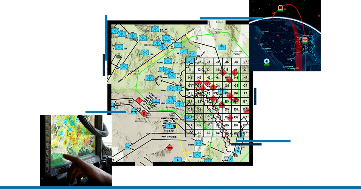
- Enterprise Situational Awareness: Delivers user-driven applications and dashboards that harmonize efforts across domains, functions, and echelons — from strategic command to tactical operators.
Use Cases
- Military intelligence analysts fusing multi-source data into common operating pictures for threat assessment and mission planning.
- Operations staff planning and monitoring maneuver operations with real-time terrain, weather, and force disposition overlays.
- Readiness officers tracking equipment status, personnel locations, and supply chain data on an integrated geospatial dashboard.
- Defense IT teams embedding geospatial services into custom command-and-control (C2) or logistics mission systems via ArcGIS APIs.
- Forward-deployed units maintaining geospatial awareness and sharing mission-critical data in low-bandwidth or disconnected field environments.
Pros
- Battle-Tested Resilience: Native DDIL support ensures geospatial capabilities remain available even in austere or communications-degraded environments critical to military missions.
- Broad Interoperability: Open architecture and adherence to geospatial standards allow seamless integration with thousands of defense mission systems worldwide.
- Scalable Across All Echelons: Used by militaries at every level of command — from theater headquarters to tactical units — providing consistent data and tools across the force.
- Flexible Deployment Options: Supports cloud (AWS, Azure), private cloud, and on-premises deployments, giving organizations full control over data sovereignty and security.
Cons
- Opaque Enterprise Pricing: Licensing costs are not publicly listed and require direct engagement with Esri sales, making budget estimation difficult for smaller organizations or new adopters.
- Steep Learning Curve: The breadth and complexity of the ArcGIS platform can require substantial training and onboarding for personnel to use it effectively across all functions.
- Infrastructure Requirements: Deploying ArcGIS Enterprise at scale demands significant IT infrastructure investment, including server capacity, network planning, and administrative expertise.
Frequently Asked Questions
What is ArcGIS Defense used for?
ArcGIS Defense is used by military and defense organizations for intelligence analysis, operational planning, logistics readiness tracking, and situational awareness across all warfighting functions and echelons.
Does ArcGIS Defense work in disconnected environments?
Yes. ArcGIS supports DDIL (denied, disconnected, intermittent, and low-bandwidth) environments. Data can be provisioned and replicated across deployment patterns so operations continue even without a live network connection.
Can ArcGIS Defense be deployed in the cloud?
Yes. ArcGIS Enterprise supports deployment on Amazon Web Services (AWS) and Microsoft Azure, as well as on-premises and private cloud environments, giving organizations flexibility in their IT strategy.
How does ArcGIS integrate with existing defense mission systems?
ArcGIS is built on an open, service-based architecture that supports standard geospatial data formats, APIs, and protocols. This enables it to be embedded into or connected to existing mission systems with minimal customization.
Who uses Esri ArcGIS Defense?
ArcGIS Defense is used by military forces, intelligence agencies, and defense contractors globally. It supports roles ranging from senior commanders and intelligence analysts to logistics officers and field operators.