
About
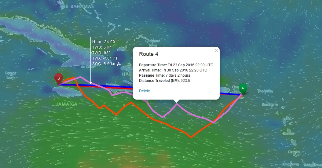
FastSeas is a specialized weather routing platform designed for sailors and offshore passage makers. It leverages the latest NOAA GFS (Global Forecast System) model data and NOAA OSCAR ocean current data to compute the optimal route between any two points on the water, taking into account wind speed and direction, ocean currents, vessel polar performance, and the skipper's comfort preferences. The routing algorithm actively routes vessels through areas of favorable current while avoiding contrary ones, and uses up to 16 days of forecast data for long-distance passages. FastSeas also provides a Departure Planning feature to help sailors select the best window to set sail. For offshore and bluewater sailors, the premium tier includes an Email Responder that integrates with satellite and radio email systems including Iridium GO!, Sailmail, Winlink, and Garmin inReach — enabling route requests even without internet access at sea. Routes can be exported in KMZ, KML, GPX, and CSV formats for use with popular chart plotters and navigation software. The tool supports both sailboats and powerboats through customizable polar data profiles. FastSeas is built and maintained by Jeremy Waters, an experienced bluewater sailor who has cruised the Mediterranean, Caribbean, Bahamas, US East and Gulf Coasts, and completed a transatlantic passage. The free tier allows 5 routing requests per month, while the premium subscription offers unlimited routing and departure planning.
Key Features
- GFS Weather Routing: Calculates optimum sailing routes using NOAA GFS model data updated four times daily, with forecasts covering up to 16 days ahead.
- Ocean Current Optimization: Integrates NOAA OSCAR ocean current data to route vessels through favorable currents and away from contrary ones, improving passage time and efficiency.
- Departure Planning: Helps sailors identify the best departure window for their passage based on upcoming weather and current conditions.
- Satellite Email Responder: Premium feature supporting Iridium GO!, Sailmail, Winlink, and Garmin inReach for offshore route requests without internet connectivity.
- Multi-Format Route Export: Export calculated routes in KMZ, KML, GPX, and CSV formats for seamless integration with chart plotters and navigation apps.
Use Cases
- Planning an offshore bluewater passage such as a transatlantic or Pacific crossing with optimized routing based on wind and current forecasts.
- Selecting the ideal departure window for a coastal or offshore trip to avoid adverse weather and take advantage of favorable conditions.
- Requesting optimized sailing routes via satellite email while underway offshore without internet access, using Iridium GO! or Winlink.
- Comparing route options for racing or performance sailing by inputting custom vessel polar data to maximize speed made good.
- Cruising route planning across extended voyages in areas like the Caribbean, Mediterranean, or Bahamas using up to 16 days of forecast data.
Pros
- Free tier available: Sailors can access weather routing and departure planning at no cost, with 5 requests per month — ideal for occasional passage makers.
- Uses authoritative NOAA data: Relies on official GFS and OSCAR datasets updated multiple times daily, providing reliable and current forecast accuracy.
- Satellite comms integration: Premium Email Responder supports major offshore communication systems, enabling bluewater sailors to receive routing while at sea.
- Vessel performance customization: Supports custom polar data for both sailboats and powerboats, allowing accurate route optimization based on your specific vessel.
Cons
- Limited free tier: The free plan caps users at only 5 weather routing and 5 departure planning requests per month, which may be insufficient for active cruisers.
- No hazard avoidance: FastSeas does not account for reefs, navigational hazards, cyclones, or piracy risks — sailors must cross-reference with official charts.
- Web-only platform: There is no dedicated mobile app, limiting access to onboard use cases where a browser and internet connection are available.
Frequently Asked Questions
What weather forecast data does FastSeas use?
FastSeas uses the latest NOAA GFS (Global Forecast System) model data, updated four times daily at approximately 05:00, 11:00, 17:00, and 23:00 UTC. The routing calculations incorporate up to 16 days of forecast data.
Does FastSeas take ocean currents into account?
Yes. FastSeas uses NOAA OSCAR ocean current data to automatically route vessels through areas of beneficial current and avoid areas of contrary current, improving overall passage efficiency.
What is the difference between the free and premium plans?
The free Basic plan allows 5 weather routing requests and 5 departure planning requests per month. The Premium plan offers unlimited requests, plus access to the Email Responder feature for satellite and radio email systems (Iridium GO!, Sailmail, Winlink, Garmin inReach).
Can I use FastSeas with my chart plotter?
Yes. FastSeas allows you to export calculated routes in KMZ, KML, GPX, and CSV formats, which are compatible with most popular chart plotters and navigation software.
Will FastSeas keep me safe from reefs, hurricanes, or piracy?
No. FastSeas is a routing optimization tool based on weather and current data only. It does not avoid reefs, navigational hazards, cyclones, or piracy risks. Every captain remains responsible for the safety of their vessel and crew.