

About
GoodMaps is an AI-driven indoor navigation and wayfinding solution built on a foundation of inclusivity and accessibility. Leveraging state-of-the-art LiDAR imaging and camera-based technology, GoodMaps creates high-accuracy 3D point cloud maps of indoor environments, enabling navigation precision down to the foot — all without requiring any physical hardware or complex infrastructure installations. Designed with blind and visually impaired users in mind, the GoodMaps mobile app allows individuals to navigate complex indoor spaces — such as supermarkets, transit stations, hospitals, and corporate campuses — independently and confidently. The platform also benefits sighted users through intuitive wayfinding interfaces. Venues across multiple industries — including transportation, retail, healthcare, education, government, and recreation — can enhance their spaces using GoodMaps Studio, a dedicated tool for mapping and managing indoor environments. The solution integrates seamlessly through web maps, a mobile app, and a Scan & Go feature for effortless deployment. GoodMaps serves a broad ecosystem of partners and has real-world deployments in major venues like Walmart Mexico, proving its scalability from small clinics to large arenas. Its developer resources and API access make it extensible for custom integrations. By removing barriers to independent exploration, GoodMaps fulfills a mission of navigation for all — advancing both accessibility standards and venue engagement across the globe.
Key Features
- LiDAR-Powered 3D Mapping: Uses state-of-the-art LiDAR imaging and camera-based technology to generate high-accuracy 3D point cloud maps of indoor environments, achieving foot-level precision.
- No Hardware, Zero Installations: Deploys without any physical infrastructure or complicated hardware, making setup and ongoing maintenance effortless for venue operators.
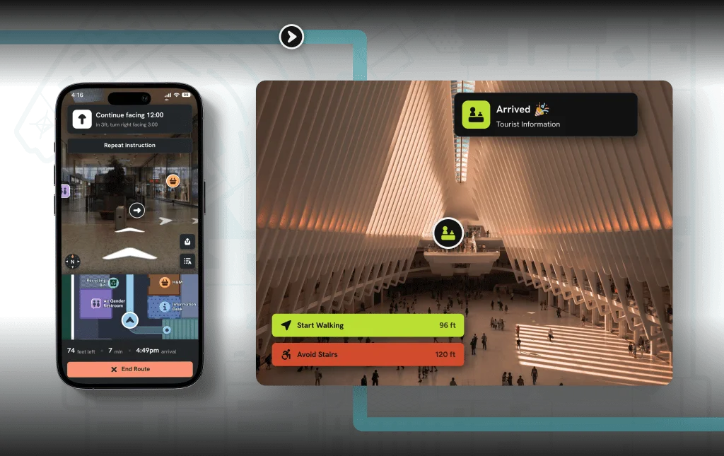
- Inclusive Mobile App: A purpose-built mobile application that enables blind, visually impaired, and all users to navigate complex indoor spaces independently and confidently.
- Multi-Industry Venue Support: Supports a wide range of industries including airports, retail malls, hospitals, universities, stadiums, government buildings, and more.
- GoodMaps Studio & Developer API: Venue operators can manage and update indoor maps via GoodMaps Studio, while developers can extend functionality through dedicated API and SDK access.
Use Cases
- A blind shopper uses the GoodMaps app to independently navigate a large Walmart store, locate specific products, and check out without requiring assistance from store staff.
- An airport deploys GoodMaps to help visually impaired travelers find gates, restrooms, and amenities within the terminal without hardware installation.
- A hospital integrates GoodMaps to guide patients and visitors through complex multi-floor facilities, improving the experience for people with and without visual impairments.
- A university campus uses GoodMaps to make academic buildings and libraries accessible to students with disabilities, fulfilling ADA compliance and inclusion goals.
- A sports arena enables GoodMaps wayfinding so all attendees — including those with mobility or vision challenges — can independently locate seats, concessions, and exits.
Pros
- Truly Inclusive Design: Built from the ground up for accessibility, empowering blind and visually impaired users to shop, travel, and navigate public spaces without assistance.
- No Infrastructure Required: Unlike beacon-based systems, GoodMaps requires no hardware installation, drastically lowering deployment costs and maintenance overhead for venues.
- High Accuracy Navigation: LiDAR-based mapping delivers foot-level precision, making it reliable even in large or complex indoor environments like airports or hospitals.
- Broad Industry Applicability: Works across transportation, retail, healthcare, education, government, and recreation sectors, making it a versatile enterprise solution.
Cons
- Venue-Dependent Coverage: The app's usefulness depends on whether a specific venue has been mapped and partnered with GoodMaps, limiting availability in many locations.
- Enterprise-Focused Pricing: Venue integration is a B2B service likely involving custom pricing, which may be a barrier for smaller organizations or independent businesses.
- Requires Initial LiDAR Scanning: Each venue must undergo a professional LiDAR scanning process before becoming available on the platform, adding an onboarding step for new locations.
Frequently Asked Questions
What is GoodMaps and who is it for?
GoodMaps is an AI-powered indoor navigation platform designed to provide inclusive wayfinding for everyone, with a particular focus on empowering blind and visually impaired individuals to navigate complex venues independently. It serves both end users (via the free mobile app) and venue operators (via a B2B mapping and deployment service).
Does GoodMaps require special hardware to be installed in a venue?
No. GoodMaps is hardware-free and requires no physical installations like Bluetooth beacons or Wi-Fi anchors. It uses LiDAR scanning and camera-based technology to create accurate indoor maps without any on-site infrastructure.
How accurate is GoodMaps indoor navigation?
GoodMaps achieves high accuracy down to the foot level, thanks to its state-of-the-art LiDAR imaging and 3D point cloud mapping technology.
Which industries and venue types does GoodMaps support?
GoodMaps supports a wide variety of industries including transportation (airports, rail stations), retail (malls, supermarkets), healthcare (hospitals, clinics), education (universities, schools), corporate offices, recreation venues (stadiums, arenas), community spaces (museums, libraries), and government buildings.
How can my venue get set up with GoodMaps?
Venues can contact GoodMaps directly through their website to get started. The process involves LiDAR scanning of the venue space and onboarding through GoodMaps Studio, the platform's venue management tool.