
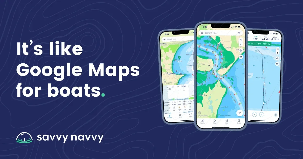

About
Savvy Navvy is a comprehensive marine navigation app designed for recreational and professional boaters alike. Often described as 'Google Maps for boats,' it consolidates everything needed for safe, efficient on-water navigation into a single, clean interface available on iOS, Android, and web. The app features Savvy Charts™, built from officially licensed UKHO, NOAA, and global hydrographic office data, rendered with a modern UI optimised for reading at sea. Smart Routing leverages AI to calculate optimal passages by factoring in departure time, boat specifications, tidal conditions, wind, and weather — producing a comprehensive, tailored passage plan. Over the Horizon AIS (OHA) streams live vessel data via internet connection to improve collision awareness, while NMEA Connect integrates onboard instruments such as depth, wind, speed, and AIS directly into the app. Marine weather is powered by ECMWF technology, combining multiple forecast models into a more accurate outlook complete with scrollable wind, rain, and cloud overlays. The Waves feature translates sea-state data into an easy-to-read comfort rating. Additional tools include live GPS tracking with COG/SOG readouts, tide data, arrival time and fuel estimation, and custom waypoint marking. Savvy Navvy has earned multiple industry awards including Boating Industry Awards Top Products 2025 and MMA Neptune Best Product Launch 2024. Core navigation features are free with no credit card required, while a Premium subscription unlocks full global chart coverage and advanced routing. Ideal for sailors, offshore cruisers, inshore fishermen, and anyone who needs reliable, modern on-the-water navigation.
Key Features
- AI-Powered Smart Routing: Calculates the optimal passage plan by factoring in departure time, boat specifications, tidal conditions, wind, and weather to produce a reliable, tailored voyage plan.
- Savvy Charts™: Official hydrographic charts licensed from UKHO, NOAA, and global sources, redesigned from the ground up with a clean, easy-to-read mobile interface.
- Over the Horizon AIS (OHA): Streams live AIS vessel data via internet connection, displaying speed, position, COG, MMSI, and destination of nearby vessels for enhanced situational awareness.
- ECMWF Marine Weather Forecasts: Combines multiple weather models for a comprehensive multi-day forecast with scrollable wind, rain, and cloud overlays plus a sea-state waves comfort rating.
- NMEA Connect: Integrates real-time onboard instrument data — depth, wind speed, boat speed, and AIS — directly into the app alongside smart routing for a unified cockpit experience.
Use Cases
- Planning offshore sailing passages with AI-optimised routing that accounts for weather windows, tidal streams, and individual boat performance.
- Inshore and coastal fishing — marking waypoints for favourite fishing spots, monitoring tidal currents, and navigating back to the harbour safely.
- Weekend cruising and family boating trips that require an easy-to-understand, visually clear navigation tool for less experienced crew members.
- Using the app as a reliable backup navigation system when primary onboard instruments or chart plotters fail at sea.
- Passage planning research and route preparation before departure, reviewing tidal gates, weather windows, and fuel requirements from a desktop or mobile browser.
Pros
- All-in-One Navigation Platform: Consolidates charts, weather, tides, AIS, routing, and instrument integration into a single mobile app, eliminating the need for multiple separate tools.
- Free to Get Started: Core features are available at no cost with no credit card required, making the app immediately accessible to casual and first-time boaters.
- Award-Winning and Highly Rated: Over 3 million downloads, 10,000+ five-star reviews, and multiple industry awards confirm its reliability, accuracy, and quality.
- Official Chart Data: Charts are sourced from official hydrographic offices including UKHO and NOAA, ensuring accuracy and trustworthiness for real-world navigation.
Cons
- Premium Required for Full Chart Coverage: Complete global chart access and the most advanced routing features are locked behind a paid Premium subscription.
- Some Features Require Internet Connectivity: OHA AIS streaming and live weather updates depend on a mobile data connection, which may not always be available in offshore or remote waters.
- Not a Certified Commercial Navigation System: Like all consumer mobile apps, Savvy Navvy is not certified as a primary navigation system for SOLAS-regulated or commercially licensed vessels.
Frequently Asked Questions
Is Savvy Navvy free to use?
Yes. Savvy Navvy offers a free tier covering core navigation features with no credit card required. A Premium subscription unlocks full global chart coverage and advanced smart routing capabilities.
What platforms is Savvy Navvy available on?
Savvy Navvy is available on iOS via the App Store, Android via Google Play, and as a web app accessible through a browser.
How does Smart Routing work?
Smart Routing uses AI to analyse your planned departure time, boat specifications, chart data, tidal conditions, wind, and weather forecasts to calculate the safest and most efficient passage plan automatically.
What chart data does the app use?
Savvy Charts™ are built from officially licensed data provided by UKHO, NOAA, and other recognised hydrographic offices around the world, then redesigned for a clean and intuitive mobile display.
Can Savvy Navvy connect to my boat's onboard instruments?
Yes. The NMEA Connect feature integrates with your vessel's instruments over a network connection to stream real-time depth, wind speed, boat speed, and AIS data directly into the app.