
S
About
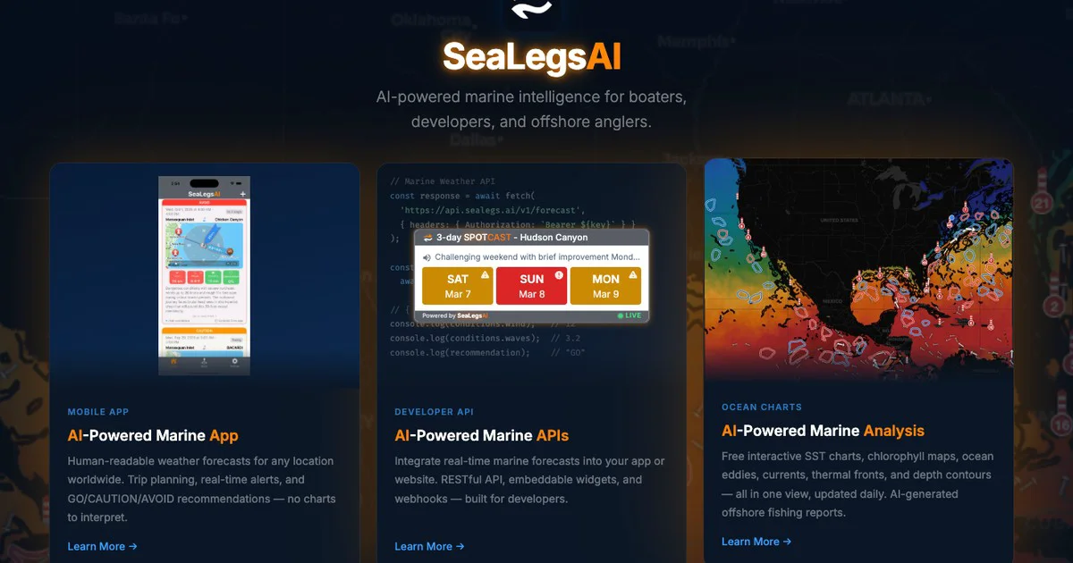
SeaLegsAI is a specialized AI marine intelligence platform serving three distinct audiences: recreational boaters, offshore anglers, and software developers. For boaters, it translates raw marine meteorological data into plain-language weather forecasts covering wind, waves, visibility, and overall go/no-go conditions for any location worldwide—no chart-reading expertise required. For anglers, it delivers daily AI-powered fishing reports synthesized from sea surface temperature (SST) charts, chlorophyll concentration maps, ocean eddy tracking, current analysis, and thermal front detection, helping users locate productive fishing grounds with precision. For developers, SeaLegsAI offers a robust RESTful API that returns structured forecast data including wind speed, wave height, and AI-generated recommendations in JSON format. The platform also provides embeddable widgets for easy web integration and webhook support for event-driven architectures. Built by SeaLegs LLC, the platform combines satellite-derived oceanographic datasets with AI processing to make professional-grade marine intelligence accessible to everyday users and application builders. Ideal for recreational boaters, charter captains, offshore fishing enthusiasts, maritime app developers, and any business needing real-time ocean and weather data.
Key Features
- AI Marine Weather Forecasts: Provides plain-language, easy-to-read marine weather forecasts for any global location covering wind, waves, and visibility—no chart interpretation needed.
- AI-Powered Offshore Fishing Reports: Daily fishing reports built from sea surface temperature (SST), chlorophyll maps, ocean eddies, currents, and thermal fronts to help anglers find fish.
- RESTful Marine Weather API: Developer-friendly API returning structured JSON with real-time marine conditions, wave height, wind speed, and AI go/no-go recommendations via a simple Bearer token.
- Embeddable Widgets & Webhooks: Drop-in embeddable widgets for websites and webhook support for event-driven integrations, making it easy to add marine intelligence to any platform.
- Oceanographic Data Layers: Integrates satellite-derived SST charts, chlorophyll concentration, ocean eddy tracking, and thermal front analysis for deep marine situational awareness.
Use Cases
- A recreational boater checks SeaLegsAI before a weekend trip to get a plain-language go/no-go forecast without needing to interpret raw NOAA charts.
- An offshore fishing charter captain uses daily AI fishing reports with SST and eddy data to plan routes to productive fishing grounds and brief clients.
- A marine app developer integrates the SeaLegsAI RESTful API to display real-time wave height and wind speed widgets on a sailing route planner website.
- A yacht club embeds SeaLegsAI widgets on their member portal to provide up-to-date local marine conditions for race participants.
- A maritime SaaS startup uses SeaLegsAI webhooks to trigger automated alerts when sea conditions exceed safe thresholds for their fleet tracking platform.
Pros
- Highly Specialized Marine Focus: Unlike generic weather apps, SeaLegsAI is purpose-built for marine environments, providing ocean-specific metrics like SST, eddies, and chlorophyll unavailable elsewhere in one place.
- No Expertise Required: AI processing converts complex meteorological and oceanographic data into plain-language forecasts, making professional-grade marine intelligence accessible to non-experts.
- Developer-Ready Infrastructure: Clean RESTful API with JSON responses, embeddable widgets, and webhook support enables quick integration into third-party apps, websites, and automated systems.
- Global Coverage: Marine weather forecasts and oceanographic data are available for any location worldwide, not limited to specific coastal regions.
Cons
- Very Niche Use Case: Useful only for marine-related activities; not applicable for general-purpose weather, land-based navigation, or non-maritime industries.
- Pricing Transparency: Pricing details for the API and premium tiers are not clearly displayed on the public site, making cost estimation difficult before signing up.
- Limited Integration Ecosystem: As a specialized platform, it lacks pre-built integrations with popular tools like Zapier or major mapping platforms compared to broader weather APIs.
Frequently Asked Questions
What makes SeaLegsAI different from a regular weather app?
SeaLegsAI is purpose-built for marine environments. It goes beyond standard wind and rain forecasts by incorporating sea surface temperature, chlorophyll maps, ocean eddies, thermal fronts, and wave height—data critical for safe boating and productive fishing that general weather apps don't provide.
How do the AI fishing reports work?
SeaLegsAI's fishing reports are generated daily by processing satellite-derived oceanographic data including SST charts, chlorophyll concentrations, ocean eddy positions, current patterns, and thermal fronts. The AI synthesizes these layers to identify likely fish-holding areas and conditions.
Who is the Marine Weather API designed for?
The API is designed for developers and businesses who want to integrate real-time marine forecasts into their own apps, websites, or services. It supports RESTful requests with Bearer token authentication, returns JSON responses, and includes embeddable widgets and webhooks for flexible integration.
What data does the API return?
The API returns structured marine forecast data including wind speed, wave height, visibility, and an AI-generated recommendation (e.g., 'GO' or 'NO-GO') indicating overall conditions for boating or offshore activities.
Is SeaLegsAI available for locations outside the United States?
Yes, SeaLegsAI provides AI-powered marine weather forecasts for any location worldwide, making it useful for international boaters, anglers, and developers building global maritime applications.