

About
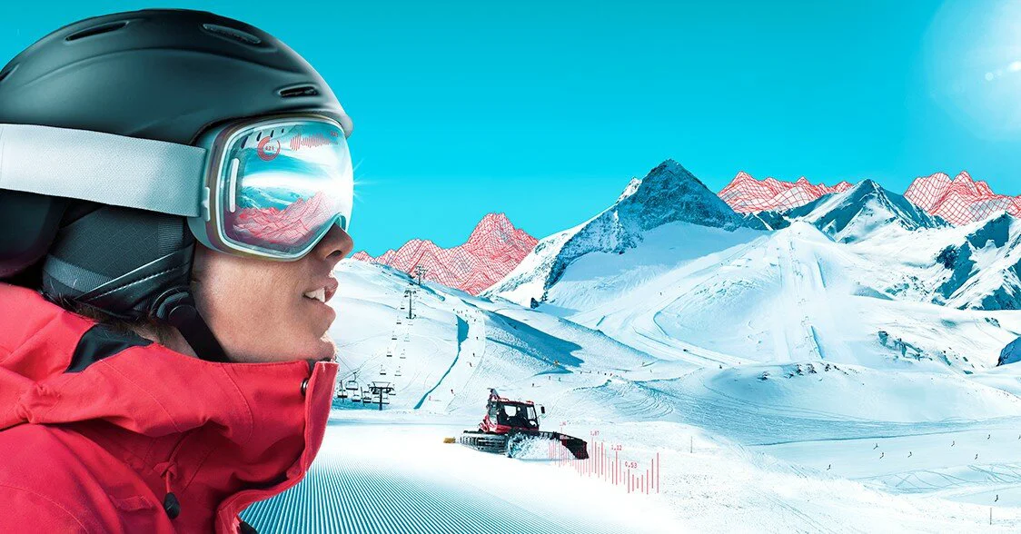
SNOWsat LiDAR is an enterprise-grade digital management suite developed for ski areas and cable car operators seeking to modernize and optimize their operations. At its core, the SNOWsat LiDAR Suite delivers predictive, high-precision snow depth measurement using LiDAR sensor technology, allowing resort managers to optimize snowmaking schedules, open slopes earlier, and reduce resource consumption. Beyond snow measurement, SNOWsat offers a unified platform encompassing four key management pillars: Piste Management for snow planning and grooming optimization; Fleet Management for monitoring and analyzing snowcat fleets with driver orientation tools; Maintenance Management via SNOWsat Maintain, which digitizes asset maintenance workflows; and Area Management for maintaining an up-to-date digital twin of the entire resort using geodata. The SNOWsat iX application is purpose-built for use inside piste vehicles, giving operators real-time situational awareness. All resort data is centralized, making it a single source of truth for cross-departmental communication and decision-making. The platform integrates hardware and software from multiple vendors, acting as a bridge across different systems. SNOWsat is ideal for ski resort operators, mountain railway companies, and resort management teams that want to reduce energy and material costs, improve team coordination, and gain a competitive advantage through data-driven operations.
Key Features
- LiDAR Snow Depth Measurement: Uses LiDAR sensor technology for predictive, high-precision snow depth measurement across ski slopes, enabling optimized snowmaking and piste preparation.
- Piste & Snow Management: Provides real-time snow data to efficiently plan slope grooming, reduce snow waste, and open runs earlier in the season.
- Fleet Management: Monitors snowcat fleets with detailed analytics, driver orientation support, and usage reporting to improve operational efficiency and safety.
- SNOWsat Maintain – Maintenance Management: Digitizes all asset maintenance workflows, enabling standardized processes, proactive scheduling, and a comprehensive asset registry.
- Centralized Resort Data Platform: Consolidates geodata, operational data, and cross-department communication on a single platform to create a living digital twin of the entire resort.
Use Cases
- Ski resort managers using LiDAR snow depth data to plan and optimize daily slope grooming and snowmaking operations.
- Fleet supervisors monitoring snowcat usage, fuel consumption, and driver performance across an entire mountain.
- Maintenance teams digitizing asset inspection workflows and tracking equipment service history with SNOWsat Maintain.
- Resort operations directors creating a real-time digital twin of their ski area using integrated geodata and sensor feeds.
- Mountain railway operators reducing energy and resource costs by making data-driven decisions about snow distribution and slope opening schedules.
Pros
- All-in-One Resort Platform: Covers snow measurement, fleet, maintenance, and area management in a single integrated system, eliminating data silos.
- Significant Cost & Resource Savings: Precise LiDAR data and analytics help resorts reduce energy, water, and labor costs associated with snowmaking and piste grooming.
- Hardware-Agnostic Integration: Acts as a bridge between hardware and software from multiple vendors, making it flexible for existing resort infrastructure.
- Proven Industry Adoption: Trusted by major ski resorts such as Arosa Bergbahnen AG, with strong testimonials from operational staff.
Cons
- Niche Industry Focus: Designed exclusively for ski resorts and mountain railways, making it irrelevant to operators outside the winter sports industry.
- Enterprise Pricing: As a specialized enterprise platform, pricing is not publicly disclosed and likely requires a custom quote, which may be a barrier for smaller resorts.
- Language & Regional Barrier: Primary interface and documentation appear to be in German, which may limit accessibility for non-German-speaking international operators.
Frequently Asked Questions
What is SNOWsat LiDAR?
SNOWsat LiDAR is a specialized module of the SNOWsat platform that uses LiDAR sensor technology to deliver high-precision, real-time snow depth measurements across ski slopes, enabling optimized piste preparation and snowmaking planning.
What does the full SNOWsat platform include?
The SNOWsat platform includes the LiDAR Suite for snow measurement, Piste Management, Fleet Management, Area Management (geodata), and SNOWsat Maintain for digitized maintenance workflows — all accessible from a centralized dashboard.
Who is SNOWsat designed for?
SNOWsat is designed for ski resort operators, mountain railway companies, piste and rescue service managers, and maintenance teams who want to digitize and optimize their resort operations year-round.
How does SNOWsat help reduce costs?
By providing precise snow depth data, SNOWsat allows resorts to use existing snow more efficiently, reduce unnecessary snowmaking, open slopes earlier, and streamline fleet and maintenance operations — all of which contribute to measurable cost savings.
Can SNOWsat integrate with existing hardware and software?
Yes. SNOWsat is designed to act as a bridge between hardware and software systems from different manufacturers, making it compatible with existing resort infrastructure and vendor ecosystems.