

About
Urban SDK is a purpose-built geospatial AI platform designed for government agencies, city planners, law enforcement, and transportation authorities. It delivers granular, route-level traffic intelligence—including hourly speed, volume, travel time delay, and collision risk data—on every road, empowering public sector leaders to make faster, data-driven decisions. The platform replaces costly and time-consuming manual data collection with automated workflows and AI-powered analytics. Users can sketch custom zones on an interactive map, visualize time-driven patterns with dynamic timelapse, and toggle between detailed and aggregated views for quick situational awareness. Key use cases include proactive traffic enforcement for police and highway patrols, automated traffic calming project requests for public works departments, infrastructure resilience planning for emergency management, and traffic operations optimization for state DOTs and transit agencies. Urban SDK also provides a Collision Index for dangerous road risk scoring, Linear Referencing System GIS matching for roadway management, and mobility data to support transportation planning. Its intuitive design means agencies can go from raw data to actionable insights without deep technical expertise. With proven ROI across 300+ North American communities, Urban SDK helps governments prioritize resources, reduce risk, and advance operational efficiency—all powered by geospatial AI built specifically for the public sector.
Key Features
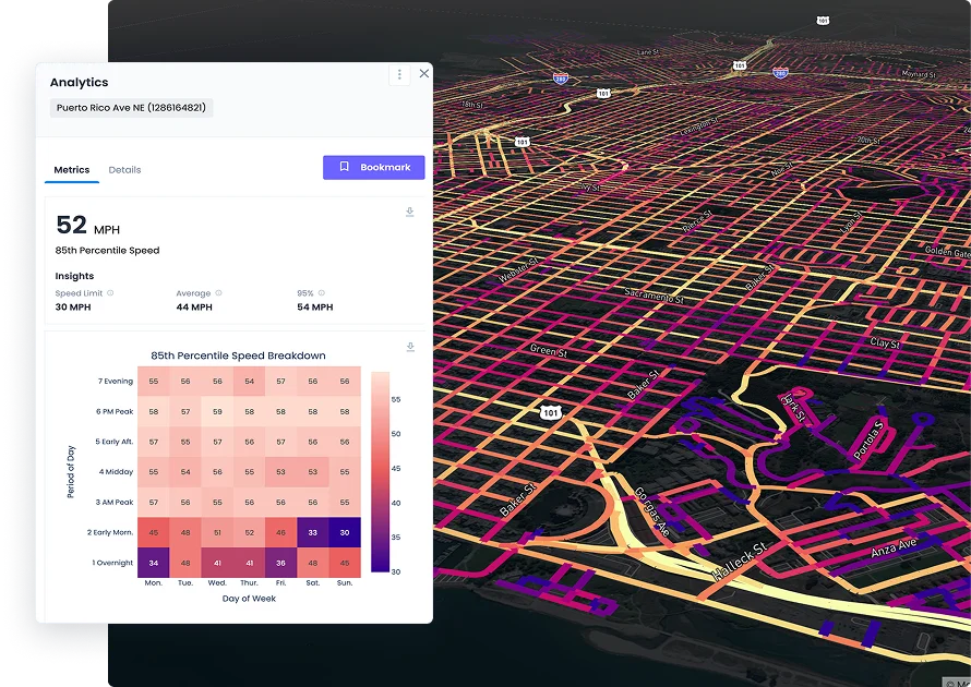
- Hourly Route-Level Traffic Data: Access granular hourly data on traffic speed, volume, travel time delay, and AADT on every road segment for precise, real-time situational awareness.
- AI-Powered Geospatial Analytics: Use artificial intelligence to transform complex geospatial datasets into clear, actionable insights through map-based zone sketching, timelapse playback, and aggregated views.
- Collision Index & Safety Risk Scoring: Identify the most dangerous roads and pedestrian risk areas using a data-driven collision index that scores roadway hazard levels for proactive intervention.
- Automated Workflow Replacement: Replace manual traffic data collection, analysis, and reporting tasks with a single unified platform, saving hundreds of hours per year for public agencies.
- Emergency & Disaster Response Tools: Equip emergency management teams with geospatial AI for natural disaster preparation, infrastructure mitigation planning, and real-time response operations.
Use Cases
- A city police department uses Urban SDK to identify top speeding corridors and deploy targeted traffic enforcement, reducing accidents on high-risk roads.
- A public works department automates the validation and processing of traffic calming requests—such as speed bumps or signal changes—cutting project timelines from months to days.
- A state emergency management agency leverages geospatial AI to map infrastructure vulnerabilities before hurricane season, enabling proactive mitigation and faster disaster response.
- A regional transit authority analyzes travel time delay data across key routes to optimize signal timing and reduce commuter delays throughout the network.
- A school district uses collision risk scoring and traffic volume data to identify dangerous drop-off zones and advocate for infrastructure improvements near schools.
Pros
- Comprehensive Traffic Intelligence: Provides hourly, route-level data on speed, volume, travel time, and collision risk—covering virtually every road without requiring manual sensor installation.
- Multi-Agency Applicability: Serves a wide range of public sector needs—law enforcement, public works, DOTs, transit agencies, school districts, and emergency management—in one platform.
- Proven ROI at Scale: With 300+ communities served, the platform has demonstrated measurable cost and time savings by automating data workflows that previously required significant manual effort.
Cons
- Enterprise Pricing Model: Pricing is not publicly listed and requires direct sales engagement, which may be a barrier for smaller municipalities or agencies with limited budgets.
- Primarily Public Sector Focused: The platform is purpose-built for government and public agencies, making it less suitable for private-sector transportation or logistics use cases.
Frequently Asked Questions
What types of organizations use Urban SDK?
Urban SDK is designed for public sector organizations including police and sheriff departments, highway patrols, city public works departments, state DOTs, transit agencies, school districts, and emergency management offices.
What kind of traffic data does Urban SDK provide?
Urban SDK provides hourly traffic speed, traffic volume (including AADT and VMT), travel time delay, mobility location data, roadway characteristics, and a collision risk index—all at the route level on every road.
How does Urban SDK help with public safety?
Law enforcement agencies can use Urban SDK to identify speeding and collision hotspots, enabling proactive and targeted traffic enforcement through built-in case management tools rather than reactive responses.
Does Urban SDK require technical expertise to use?
No. The platform is designed to be accessible to non-technical users in government roles. Features like map-based zone sketching, timelapse playback, and hover-based snapshots make complex data easy to interpret without GIS or data science expertise.
How is Urban SDK priced?
Urban SDK uses a custom pricing model tailored to each organization's needs. Prospective customers can request pricing directly through the website's 'Get Pricing' option, typically engaging with the sales team for a quote.