

About
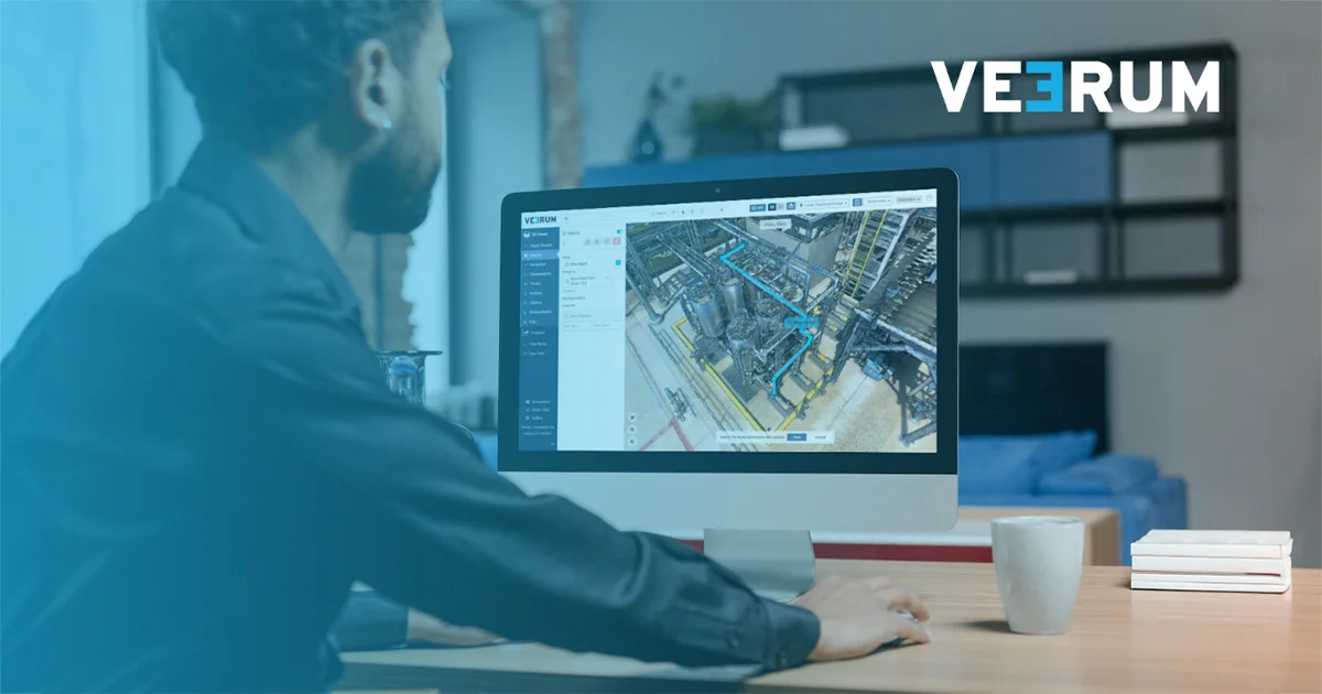
VEERUM is the world's first Visual Operations (VisOps) platform, purpose-built for industrial organizations that need to manage and collaborate on complex physical assets remotely. By transforming reality capture data — including 360° panoramas, point clouds, and CAD models — into an interactive, georeferenced 3D environment accessible entirely through a browser, VEERUM eliminates the need for costly and time-consuming on-site visits. Teams across Oil & Gas, Mining, Power & Utilities, and Industrial Construction use VEERUM to track construction progress, conduct remote site inspections, maintain asset register integrity, and collaborate in real time with internal and third-party stakeholders. Users can leave comments directly in 3D, take digitally verified measurements, tag and georeference data, and integrate with custom APIs for enterprise-scale deployments. VEERUM offers four tiered plans — Starter, Essential, Pro, and Pro+ — to accommodate teams ranging from basic data management to full-scale enterprise collaboration with expert geospatial support. Clients have reported more than 15x return on investment, and the platform is trusted by organizations representing over $1 trillion in combined market capitalization. VEERUM is ideal for operations managers, project engineers, asset managers, and enterprise teams that need a reliable, scalable visual data hub.
Key Features
- Remote 3D Site Visits: Access fully interactive 3D environments of your industrial sites from any browser, eliminating the need for expensive or hazardous on-site visits.
- Unified Visual Data Sets: Combine 360° panoramas, point clouds, and CAD models into a single georeferenced platform for a complete picture of your assets.
- Real-Time Collaboration: Comment directly in 3D, invite third-party stakeholders, and keep all teams aligned with shared views and live updates.
- Asset Register Integrity: Tag, georeference, and verify asset data with digitally verified measurements to maintain accurate and auditable records.
- Enterprise API Integration: Pro+ plan users can integrate VEERUM with custom APIs and access dedicated enterprise and geospatial support for large-scale deployments.
Use Cases
- Construction progress tracking: project managers upload UAV scan data biweekly or monthly to monitor site advancement and keep stakeholders aligned without site visits.
- Remote asset inspections: operations teams conduct visual inspections of oil rigs, mining equipment, or utility infrastructure from a browser, reducing downtime and travel risk.
- Third-party collaboration: engineering consultants or contractors are invited into the 3D environment to review plans, add comments, and take measurements without needing on-site access.
- Asset register maintenance: teams tag, georeference, and verify equipment in 3D to ensure asset records remain accurate, auditable, and up to date.
- Project planning meetings: leadership uses VEERUM's shared 3D view as a live meeting tool to navigate project sites, identify issues, and align decisions in real time.
Pros
- Eliminates Unnecessary Site Visits: Teams can conduct inspections, track progress, and collaborate in 3D remotely, saving significant time and travel costs.
- Industry-Specific Depth: Built specifically for heavy industries like Oil & Gas, Mining, and Power & Utilities, with workflows and tooling tailored to those operational needs.
- Scalable Tiered Plans: From basic data management (Starter) to full enterprise customization (Pro+), the platform scales with organizational complexity and budget.
- Strong ROI: Clients report over 15x return on investment, backed by 300+ years of combined industry experience on the VEERUM team.
Cons
- Niche Industrial Focus: The platform is purpose-built for heavy industry, making it less relevant for general-purpose asset management or non-industrial use cases.
- Pricing Not Publicly Listed: Plan pricing is not transparently disclosed on the website, requiring direct contact with the sales team to get accurate cost estimates.
- Learning Curve for Reality Capture Data: Getting value from the platform requires teams to have or acquire reality capture data (UAV scans, 360 cameras), which adds upfront investment.
Frequently Asked Questions
What is VisOps?
Visual Operations (VisOps) is the practice of operationalizing reality capture data — such as 360° imagery, point clouds, and CAD — to connect teams, data, and decisions into one shared 3D view of an industrial site.
Which industries does VEERUM support?
VEERUM is designed for Oil & Gas, Mining, Power & Utilities, and Industrial Construction, though it can be applied to any sector that manages large physical assets.
Do I need to visit the site to use VEERUM?
No. VEERUM enables fully remote site visits by providing an interactive 3D environment accessible through a standard web browser.
What types of data can I upload to VEERUM?
You can upload and geolocate 360° panoramas, point clouds, and CAD models, then unify them into a single visual data set for your team.
What plans does VEERUM offer?
VEERUM offers four plans: Starter (Manage & Store), Essential (Visualize & Collaborate), Pro (Contextualize & Integrate), and Pro+ (Scale & Customize with enterprise and API support).