

About
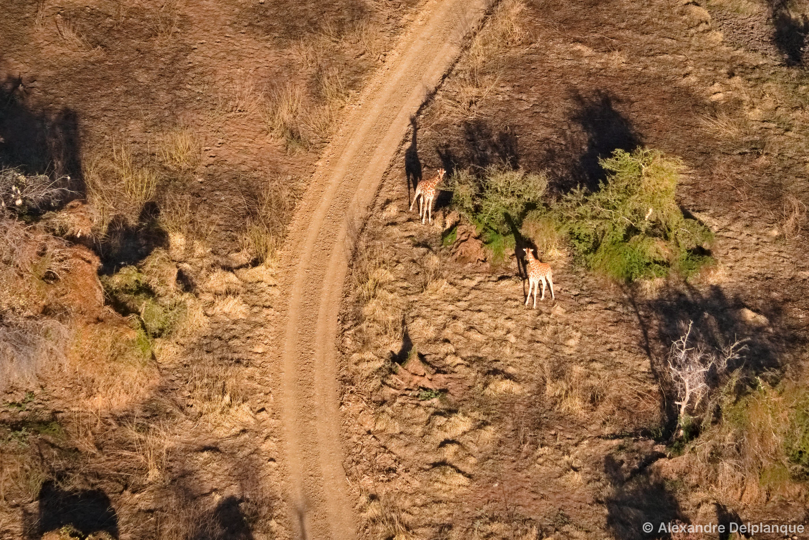
WildAI is an academic-backed, AI-driven wildlife census platform developed by researchers at the University of Liège, Gembloux Agro-Bio Tech (Belgium), in close collaboration with field conservation actors across Africa. The platform addresses a long-standing challenge in wildlife management: traditional aerial surveys conducted from light aircraft are expensive, logistically complex, and prone to human counting error. By uploading aerial photographs from drone or aircraft surveys, users can leverage WildAI's computer vision model to automatically detect and locate large mammals within imagery. Built-in reviewing tools then allow ecologists and field operators to validate detections, correct misclassifications, and produce accurate population counts and species breakdowns — all within a streamlined web interface. WildAI operates as a free, collaborative platform. In exchange for free access, users agree to have their verified detections and imagery securely stored and used to continuously retrain and improve the underlying AI model, creating a community-driven feedback loop that benefits all users over time. Key beneficiaries include wildlife researchers conducting population surveys, national park and game reserve managers tracking herd dynamics, and conservation NGOs seeking cost-effective monitoring solutions for large African mammal species. The platform is currently in the final stages of development with a public waiting list open for early access.
Key Features
- Automated Mammal Detection: AI model scans aerial photographs to automatically locate and flag large mammals, eliminating time-consuming manual image review.
- Species Identification & Counting: Provides accurate species-level identification and population counts from aerial imagery to support census data collection.
- User-Friendly Reviewing Tools: Intuitive interface lets ecologists and operators validate, correct, and confirm AI detections to ensure high-quality, audit-ready results.
- Collaborative Model Improvement: Verified user detections are securely stored and used to continuously retrain the AI, making the model smarter with every survey processed.
- Free Access for Researchers & Conservationists: Completely free to use, lowering barriers for under-resourced conservation projects and academic research teams worldwide.
Use Cases
- Conservation organizations conducting annual wildlife censuses in African national parks and game reserves.
- Academic researchers analyzing aerial survey data for large mammal population dynamics studies.
- Protected area managers tracking seasonal herd movements and species distribution across large territories.
- Wildlife NGOs seeking a cost-effective alternative to traditional manned aerial survey missions.
- Ecology students and field teams processing drone-captured imagery as part of biodiversity monitoring programs.
Pros
- Completely Free: No subscription or licensing fees, making professional-grade wildlife AI accessible to conservation teams with limited budgets.
- Reduces Cost & Human Risk: Replaces or supplements dangerous and expensive light-aircraft observation missions with safer, automated aerial photo analysis.
- Academic Rigor: Developed by University of Liège researchers with years of field collaboration across Africa, ensuring scientific credibility and methodological soundness.
- Self-Improving AI: Community-contributed verified data feeds back into model retraining, delivering progressively more accurate detections over time.
Cons
- Still in Development: The platform is not yet publicly available — users must join a waiting list, which may delay access for teams with urgent survey needs.
- Focused on Large African Mammals: Current AI models are optimized for large mammal species in African ecosystems, limiting immediate applicability to other geographies or fauna.
- Data Sharing Requirement: Free access requires users to agree to have their uploaded images and verified detections stored and used for model improvement, which may not suit all data-sensitive projects.
Frequently Asked Questions
Is WildAI really free to use?
Yes, WildAI is completely free to use. In exchange, users agree that their uploaded aerial images and verified detections are securely stored and used to improve the AI model over time.
What types of animals can WildAI detect?
WildAI's AI models are currently optimized to detect large mammals, particularly species typical of African savanna and bush ecosystems. The team continues to expand species coverage as more training data is contributed.
How does the detection process work?
Users upload aerial photographs from drone or aircraft surveys. WildAI's computer vision model automatically scans each image to locate and classify large mammals. Users then review detections through the platform's interface to validate or correct results before exporting counts.
Who developed WildAI and what is its scientific background?
WildAI was developed by a team of researchers and conservation enthusiasts at the University of Liège, Gembloux Agro-Bio Tech in Belgium. The project is the result of years of academic research on wildlife population survey methods, conducted in close collaboration with field actors across Africa.
How can I get access to WildAI?
WildAI is currently in the final stages of development. You can join the official waiting list on the WildAI website (wildai.eu) to be notified when the platform becomes available.