
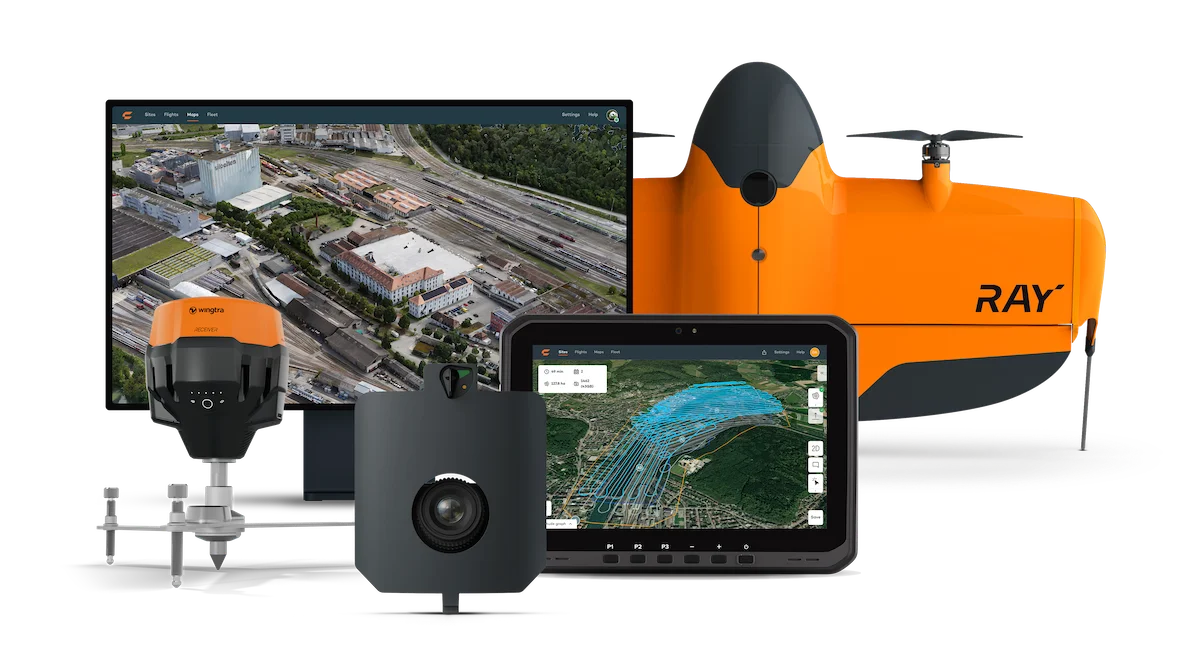

About
Wingtra delivers a fully integrated aerial survey solution designed to take teams from field collection to professional CAD and GIS-ready outputs without switching platforms. At its core are the WingtraRAY and WingtraOne GEN II VTOL drones, which combine the vertical take-off convenience of a multirotor with the long-range efficiency of a fixed-wing aircraft—enabling surveys of up to 550 ha (1,360 ac) in a single flight at 3 cm (0.1 ft) accuracy. The platform supports RGB, LIDAR, and multispectral sensor payloads, making it adaptable for a wide range of data collection needs including orthomosaics, point clouds, 3D meshes, and vegetation indices. Ground control is simplified through the GNSS WingtraGROUND Trimble kit. WingtraCLOUD, the companion software, unifies the entire workflow: flight planning with 3D obstacle avoidance, guided safety checklists, automated flight execution, cloud-based processing, team collaboration, and direct export to CAD/GIS tools. All devices stay synced in real time. Wingtra is fully approved for US operations and pre-certified for civil government use, making regulatory compliance straightforward. It is trusted across industries including urban planning, mining and metals, construction, agriculture, and environmental monitoring. Training, consulting, extended warranties, and accidental damage protection services are available to support professional operations.
Key Features
- VTOL Drone Fleet: WingtraRAY and WingtraOne GEN II drones combine vertical take-off ease with fixed-wing efficiency, covering up to 550 ha per flight.
- 3 cm Survey Accuracy: Delivers repeatable, verifiable 3 cm (0.1 ft) accuracy using guided ground control setup and GNSS integration.
- Multi-Sensor Payloads: Supports RGB, LIDAR, and multispectral sensors to capture orthomosaics, point clouds, 3D meshes, and vegetation data.
- WingtraCLOUD End-to-End Software: One connected app for flight planning, 3D obstacle avoidance, automated capture, cloud processing, team collaboration, and CAD/GIS export.
- US Regulatory Compliance: Fully approved for US airspace operations and pre-certified for civil government agency use, simplifying permitting and compliance.
Use Cases
- Surveying construction sites to generate accurate 3D models and progress reports for project management teams.
- Conducting large-scale agricultural field mapping with multispectral sensors to assess crop health and optimize inputs.
- Supporting mining operations with high-accuracy volumetric measurements and terrain models for stockpile management.
- Assisting urban planners and government agencies with orthomosaic and point cloud data for land management decisions.
- Performing environmental monitoring surveys over forests, wetlands, or disaster-affected areas to track changes over time.
Pros
- True End-to-End Workflow: Covers every step from flight planning to GIS-ready export in a single connected platform, eliminating tool-switching and data silos.
- High Coverage & Accuracy: Surveys up to 550 ha in one flight with proven 3 cm accuracy—ideal for large-scale professional projects.
- Versatile Sensor Options: RGB, LIDAR, and multispectral payloads make Wingtra adaptable across construction, agriculture, mining, and environmental use cases.
- Regulatory Readiness: Pre-approved for US civil government operations, reducing the compliance burden for public-sector and enterprise clients.
Cons
- High Upfront Investment: As a professional hardware-plus-software system, Wingtra carries a significant purchase cost that may be prohibitive for small teams or individuals.
- Hardware Dependency: The full workflow requires Wingtra's proprietary drones and sensors—the software benefits are not available as a standalone subscription.
- Training Required: Achieving consistent accuracy requires training on drone operations, ground control setup, and software usage, adding onboarding time.
Frequently Asked Questions
What is Wingtra and what does it do?
Wingtra is a professional aerial survey solution combining VTOL drones, multi-sensor payloads, and WingtraCLOUD software. It enables teams to plan flights, capture survey data, process it in the cloud, and export CAD/GIS-ready outputs—all in one connected workflow.
What accuracy can Wingtra achieve?
Wingtra delivers 3 cm (0.1 ft) accuracy that is repeatable and verifiable using guided GNSS ground control point setup and the WingtraGROUND Trimble kit.
What industries use Wingtra?
Wingtra serves urban planning and land management, mining and metals, construction and infrastructure, agriculture, environmental monitoring, and US government agencies.
Is Wingtra approved for use in the United States?
Yes. Wingtra is fully approved to operate in the US and is pre-certified for civil government agency work, making regulatory compliance straightforward.
What data outputs does Wingtra produce?
Wingtra produces orthomosaics, RGB point clouds, LIDAR point clouds, 3D meshes, and multispectral data sets—all exportable in CAD and GIS-compatible formats.