

About
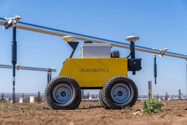
Civ Robotics is a San Francisco-based company delivering automated construction layout robots that dramatically accelerate and simplify the staking and marking process on large-scale civil and energy projects. Their flagship product line — including CivDot+, CivDot, CivDot Mini, CivNav, and CivMove — uses GPS and laser precision technology to mark coordinates as accurately as 3/100" (8mm), making them suitable for demanding terrain with built-in tilt compensation. Traditional surveying crews typically mark 200–450 points per day. With CivDot, a single operator can mark between 1,000 and 5,000 points daily, representing an up to 8x improvement in throughput. Critically, the system requires no prior land surveying experience, enabling EPCs (Engineering, Procurement, and Construction firms) to deploy general labor immediately. Civ Robotics has supported over 20 GW of solar farm and renewable energy projects across more than 5 continents, with over 10 million marked coordinates completed to date. Their solutions span solar farms, earthworks, ground improvements, airports, roads, and parking lots — making them an essential tool for large-scale infrastructure developers seeking to reduce labor costs, increase accuracy, and accelerate project timelines. The platform is trusted by top EPCs worldwide looking to modernize field operations with robotics.
Key Features
- Sub-Centimeter GPS Precision: CivDot+ marks coordinates with laser accuracy as fine as 3/100' (8mm), and CivDot achieves up to 1/10' (30mm), with tilt compensation for challenging terrain.
- 8x Faster Layout vs. Traditional Crews: One operator using CivDot can mark 1,000–5,000 points per day, compared to 200–450 for a conventional surveying crew.
- No Surveying Experience Required: The intuitive system is designed so general labor — from interns to experienced field workers — can operate it without specialized training.
- Multi-Terrain & Multi-Project Support: Suitable for solar farms, earthworks, airports, roads, parking lots, and ground improvements across diverse geographic environments on 5 continents.
- Full Robot Product Line: Offers a range of robots (CivDot+, CivDot, CivDot Mini, CivNav, CivMove) to match different project scales and accuracy requirements.
Use Cases
- Solar farm construction layout: automating coordinate staking across large photovoltaic installations to reduce crew size and accelerate timelines.
- Earthworks and grading projects: marking high-density layout points quickly on rough terrain where traditional surveying is slow and costly.
- Airport and road infrastructure: enabling precise construction staking for runways, taxiways, and road alignments with minimal specialized labor.
- Renewable energy EPC operations: allowing engineering, procurement, and construction firms to standardize and scale layout workflows across multiple project sites globally.
- Ground improvement projects: marking treatment grid points for soil stabilization and foundation preparation with centimeter-level accuracy.
Pros
- Dramatic Productivity Gains: Up to 8x improvement in daily point-marking throughput dramatically reduces project timelines and labor costs.
- Accessible to Non-Specialists: EPCs can deploy general labor to operate the equipment, eliminating dependence on scarce licensed surveyors.
- Proven at Scale: Used on 20+ GW of solar and renewable energy projects across 5 continents with 10M+ marked coordinates completed.
- High Accuracy in Difficult Conditions: Tilt compensation and GPS precision ensure reliable staking even on uneven or challenging terrain.
Cons
- Hardware-Dependent Solution: Requires purchasing or leasing physical robotic equipment, making it a significant capital investment compared to software-only tools.
- Niche Industry Focus: Primarily designed for solar farms and large civil infrastructure projects — less applicable to small-scale or residential construction.
- Pricing Not Publicly Listed: Requires direct contact with the sales team for pricing information, making upfront cost assessment difficult.
Frequently Asked Questions
What types of projects is Civ Robotics designed for?
Civ Robotics is primarily designed for large-scale civil and energy infrastructure projects including solar farms, earthworks, ground improvements, airports, roads, and parking lots.
Do operators need surveying experience to use CivDot?
No. The system is specifically engineered to be operable by general labor without prior land surveying experience, which allows EPCs to staff projects more flexibly.
How accurate are Civ Robotics layout robots?
CivDot+ achieves accuracy as fine as 3/100' (8mm), while CivDot provides up to 1/10' (30mm) accuracy. Both models include tilt compensation for use on uneven terrain.
How many points can one operator mark per day?
With CivDot, a single operator can mark between 1,000 and 5,000 points per day depending on spacing and accuracy tolerances — compared to 200–450 for a traditional two-person surveying crew.
Where has Civ Robotics technology been deployed?
Civ Robotics equipment has been used across 5 continents on over 20 GW of solar farm and renewable energy projects, with more than 10 million coordinates marked to date.