

About
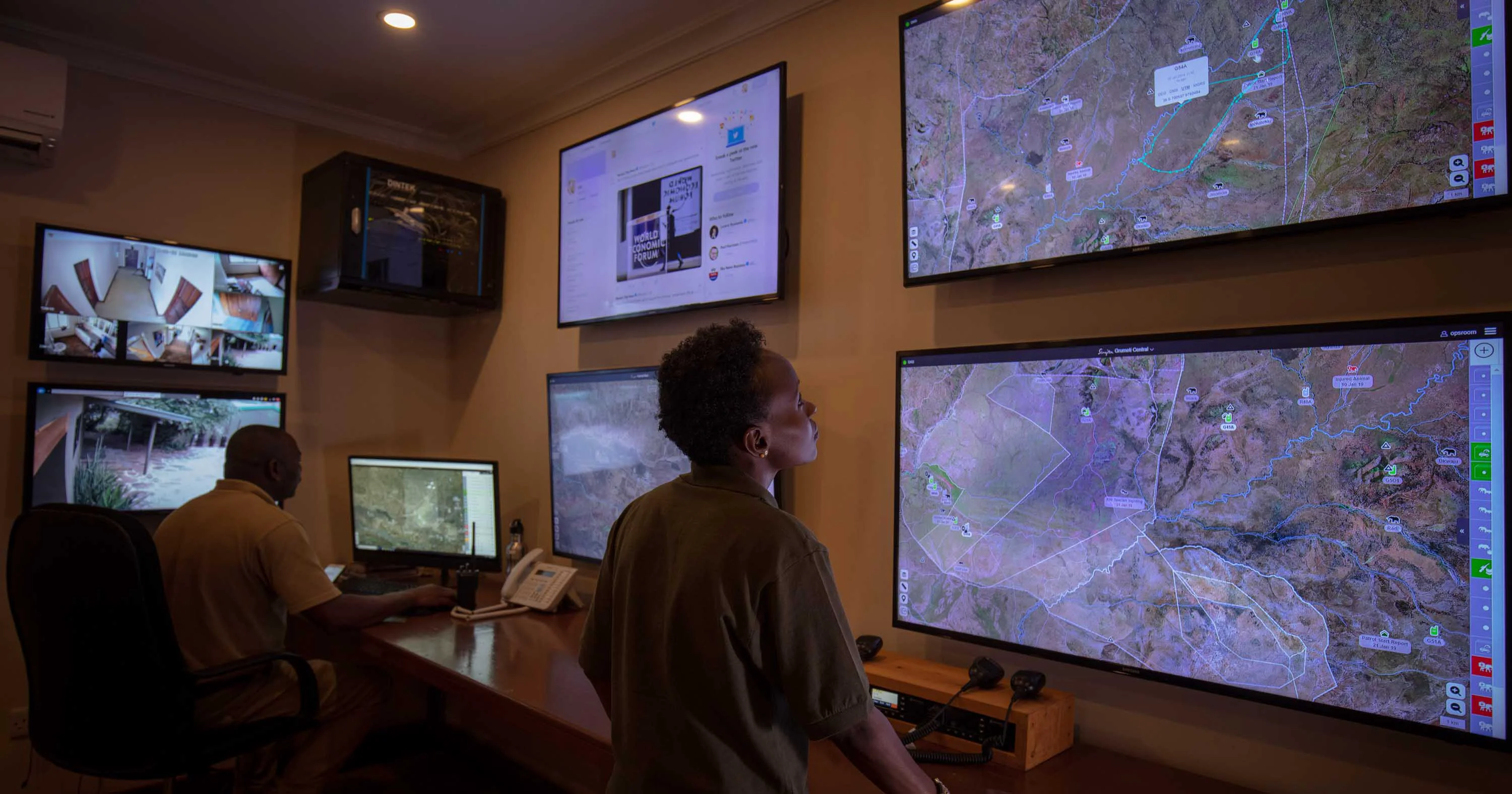
EarthRanger is a comprehensive, free-to-use conservation technology platform designed for protected area managers, ecologists, rangers, and wildlife biologists. It brings together real-time data from a wide range of sources—GPS-tagged animals, vehicle and asset trackers, camera traps, IoT sensors, aircraft trackers, and field observations—into a single unified dashboard accessible from the field or headquarters. With over 150 integrations and 23,000+ animals tracked via GPS across more than 900 supported conservation sites, EarthRanger enables teams to monitor live wildlife movements, coordinate ranger patrols, mitigate human-wildlife conflict, and protect critical habitats. Field teams can collect data offline, with automatic syncing when connectivity is restored, ensuring no observations are lost in remote areas. The platform supports instant alerts via SMS, WhatsApp, or email for key movement events such as immobility, speed changes, or boundary crossings. Heat maps, time sliders, and historical patrol reviews help teams identify patterns and refine conservation strategies. Secure, optional data sharing across protected areas and landscapes enables broader collaboration without compromising data control. EarthRanger leverages AI-driven integrations and cutting-edge satellite services alongside traditional field tools, making it a future-ready solution for conservation organizations of any size. Its focus on privacy, encryption, and configurable access makes it enterprise-grade while remaining accessible and free for conservation teams worldwide.
Key Features
- Real-Time Wildlife & Team Tracking: Monitor live movements of wildlife, vehicles, aircraft, and personnel on a shared map view accessible from both the field and command center.
- 150+ Technology Integrations: Connect animal collars, camera traps, IoT systems, satellite imagery, aircraft trackers, and more into one unified operational platform.
- Offline Field Data Collection: Capture GPS coordinates, polygons, photos, and notes offline; EarthRanger automatically syncs all data when connectivity is restored.
- Instant Alerts & Notifications: Receive SMS, WhatsApp, or email alerts triggered by key movement patterns such as immobility, speed changes, or boundary crossings.
- Data Analysis & Historical Review: Use heat maps, time sliders, base layers, and patrol history visualizations to identify trends and plan future conservation strategies.
Use Cases
- Real-time monitoring of GPS-tagged wildlife to detect poaching threats, boundary crossings, or unusual movement patterns and trigger immediate ranger response.
- Coordinating ranger patrol teams across large protected areas with live map views, in-app messaging, and personnel safety tracking.
- Mitigating human-wildlife conflict by tracking animal movements near community boundaries and issuing proactive alerts to affected villages.
- Conducting field surveys and ecological research by collecting geo-tagged observations, photos, and notes in remote areas without reliable connectivity.
- Analyzing historical patrol routes, wildlife sightings, and incident reports to identify coverage gaps and optimize future conservation strategies.
Pros
- Completely Free to Use: EarthRanger is available at no cost, making powerful conservation technology accessible to organizations of all sizes and budgets.
- Extensive Integration Ecosystem: With 150+ integrations spanning GPS devices, satellite services, and AI tools, teams can use best-in-class hardware without vendor lock-in.
- Offline-First Field Capability: Designed for remote environments where connectivity is unreliable, ensuring continuous data collection regardless of signal availability.
- Enterprise-Grade Security: Configurable access controls, encryption, and optional secure data sharing give organizations full control over sensitive conservation data.
Cons
- Niche Domain Focus: The platform is purpose-built for wildlife conservation and protected area management, making it unsuitable for general-purpose use cases.
- Requires Hardware Investment: To leverage full functionality, organizations need GPS collars, trackers, and other field hardware, which can represent a significant cost.
- Learning Curve for New Teams: The breadth of integrations and real-time data layers may require dedicated onboarding and training for teams new to conservation technology.
Frequently Asked Questions
Is EarthRanger really free?
Yes, EarthRanger is free to use for conservation organizations. There is no licensing fee for the core platform.
What types of organizations use EarthRanger?
EarthRanger is used by protected area managers, wildlife biologists, ecologists, park rangers, and conservation NGOs across 900+ sites worldwide.
Does EarthRanger work without internet connectivity?
Yes. Field teams can collect observations offline using the mobile app, and all data automatically syncs with the platform once an internet connection is restored.
What hardware and technologies does EarthRanger integrate with?
EarthRanger supports 150+ integrations including animal GPS collars, vehicle and asset trackers, camera traps, aircraft trackers, IoT systems, radios, remote imagery, and satellite services.
How does EarthRanger handle data privacy and security?
EarthRanger provides configurable access controls, end-to-end encryption, and optional secure data sharing across landscapes, ensuring organizations retain full ownership and control of their data.