

About
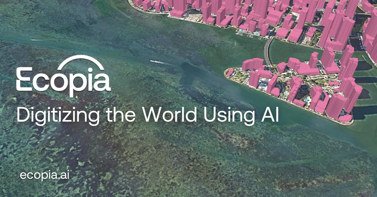
Ecopia AI is an advanced geospatial intelligence platform that leverages artificial intelligence to digitize the world by converting high-resolution imagery into comprehensive, accurate, and up-to-date vector maps. By automating what traditionally required extensive manual GIS work, Ecopia produces map data with the accuracy of a trained GIS professional but at unprecedented speed and scale. The platform's core products include 3D Land Cover mapping, Building-Based Geocoding, Advanced Transportation Features, and Global Feature Extraction. These are available through an on-demand Data Portal, enabling instant access across hundreds of cities and regions worldwide. Ecopia processes millions of square kilometers of vector data per month, drawing from a global partner network that includes providers like Nearmap, Airbus, and ESA. Ecopia serves a wide range of industries. Government agencies use it for infrastructure planning, climate resilience, and emergency preparedness. Insurance companies leverage building-level geocodes for risk assessment and underwriting. Civil engineers access accurate, current terrain and infrastructure data to streamline projects. Telecommunications firms map serviceable locations for network expansion, while NGOs utilize land cover data for humanitarian field planning. The platform continuously mines the latest imagery to keep maps current, making it a reliable foundation for data-driven decision-making across public and private sectors. Ecopia is trusted by leading organizations globally and is actively partnering to map the world in 3D.
Key Features
- AI-Powered Vector Map Extraction: Automatically converts high-resolution satellite and aerial imagery into detailed GIS-quality vector map data, eliminating the need for manual digitization.
- Global Scale & Speed: Processes millions of square kilometers of geospatial data per month, covering all terrains with unmatched speed and completeness.
- 3D Land Cover & Building Data: Offers 3D land cover mapping, building-based geocoding, and advanced transportation features available for instant access across 400+ US cities and global regions.
- Up-to-Date Global Partner Network: Integrates with leading imagery providers like Nearmap, Airbus, and ESA to ensure maps reflect the most current real-world conditions.
- Industry-Specific Data Products: Delivers tailored geospatial intelligence for government, insurance, civil engineering, telecommunications, and NGOs through a self-serve Data Portal and API.
Use Cases
- Municipal governments mapping infrastructure, land use, and stormwater systems to improve urban planning and public safety.
- Insurance companies using building-based geocodes and property intelligence to assess risk, streamline underwriting, and manage claims.
- Civil engineering firms accessing up-to-date terrain and infrastructure vector data to enhance project planning and efficiency.
- Telecommunications providers identifying serviceable locations and existing infrastructure to optimize broadband network expansion.
- NGOs and humanitarian organizations using detailed land cover data to plan field operations and respond to natural disasters or emergencies.
Pros
- GIS-Quality Accuracy at Scale: Delivers vector data with the precision of a trained GIS professional, but at a scale and speed impossible with manual workflows.
- Broad Industry Applicability: Serves a wide range of use cases across government, insurance, infrastructure, telecom, and humanitarian sectors with purpose-built data products.
- On-Demand Data Access: The self-serve Data Portal allows instant access to pre-processed map data, reducing time-to-insight for GIS teams.
- Continuously Updated Maps: Partnership network ensures imagery and resulting map data stay current, providing a reliable real-world representation over time.
Cons
- Enterprise-Focused Pricing: No publicly listed pricing or free tier; the platform appears tailored for large organizations and government contracts, which may limit accessibility for smaller teams.
- Niche Use Case: Primarily suited for GIS professionals and industries requiring geospatial data; not a general-purpose AI tool for broader audiences.
- Dependent on Imagery Quality: Output accuracy is tied to the resolution and currency of source imagery, which may vary by region or data partner availability.
Frequently Asked Questions
What types of data does Ecopia AI produce?
Ecopia AI produces high-precision vector map data including 3D land cover, building footprints and geocodes, transportation features, and other geospatial features extracted from high-resolution aerial and satellite imagery.
How accurate is the data compared to manual GIS work?
Ecopia's AI-based mapping systems are designed to match the accuracy of a trained GIS professional, providing a reliable and consistent source of truth for geospatial decision-making at scale.
Which industries can benefit from Ecopia AI?
Ecopia serves municipal and state governments, federal agencies, civil engineering firms, insurance companies, telecommunications providers, and non-governmental organizations (NGOs) engaged in humanitarian and land management projects.
How does Ecopia keep its maps up to date?
Ecopia maintains a global partner network with imagery providers such as Nearmap, Airbus, and ESA to continuously access the latest high-resolution imagery, which is rapidly processed by its AI systems to keep map data current.
How can I access Ecopia's geospatial data?
Ecopia offers an on-demand Data Portal where users can access pre-processed map data instantly. For custom or large-scale projects, organizations can contact Ecopia directly to discuss tailored data solutions.