
A
About
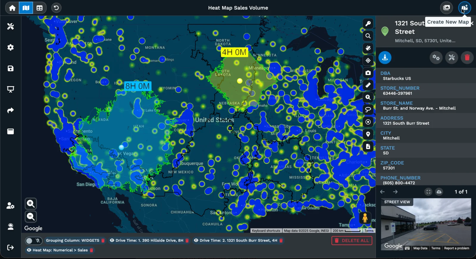
Maptive is a powerful browser-based enterprise mapping platform designed for business teams who need robust GIS capabilities without hiring specialized analysts. With over 60 built-in tools, Maptive converts raw spreadsheet data into rich geographic visualizations that reveal hidden patterns—customer clusters, coverage gaps, and unbalanced territories that traditional data tools miss. The territory management module lets users build and optimize sales regions from ZIP codes, counties, states, census tracts, or custom-drawn boundaries. Spatial analysis tools include radius mapping, drive-time polygons on real road networks, heat maps, proximity analysis, demographic overlays, and coverage gap identification. Route optimization reduces fuel costs and increases service call capacity by generating efficient multi-stop directions. Maptive simplifies stakeholder communication with polished map exports for boardroom presentations, embeddable interactive maps, and shareable protected links for external partners. The platform delivers measurable business impact: users report $100K+ in quarterly savings, 15% revenue lift from improved coverage, and 75% faster territory planning. Ideal for sales operations, logistics, regional marketing, and site selection teams, Maptive includes white-glove expert support on every plan with live mapping specialists—no bots, no scripts, no long wait times. Enterprises and growing businesses alike use Maptive to answer critical location-based questions and drive faster, data-backed decisions.
Key Features
- 60+ GIS Spatial Analysis Tools: Includes radius mapping, drive-time polygons on real road networks, heat maps, proximity analysis, demographic overlays, and coverage gap identification—all accessible in a browser with no GIS expertise required.
- Territory Management: Build and optimize sales or service territories from ZIP codes, counties, states, census tracts, or custom-drawn boundaries to balance workloads and eliminate coverage gaps.
- Route Optimization: Calculate optimized multi-stop routes on real road networks to reduce fuel costs, increase daily service call volume, and eliminate inefficient dispatching.
- Demographic & Location Intelligence: Overlay census demographics, income data, and other geographic datasets to identify high-value markets, underserved regions, and expansion opportunities.
- Stakeholder-Ready Reporting: Export polished maps for board presentations, embed interactive maps on websites, or share protected links with external partners for faster executive decision-making.
Use Cases
- Sales territory planning and rebalancing to eliminate overloaded reps and close coverage gaps across regions
- Logistics route optimization to reduce fuel costs and increase the number of daily service calls per driver
- Site selection analysis to identify optimal locations for new offices, retail stores, or service centers based on demographics and proximity data
- Regional marketing spend optimization using demographic overlays to target high-income ZIP codes with no existing coverage
- Executive stakeholder presentations with polished, shareable geographic visualizations that accelerate approval and decision-making
Pros
- No GIS Expertise Required: Enterprise-grade GIS capabilities are packaged in an intuitive interface that analysts and managers can use without any technical mapping background.
- Proven Business ROI: Users report $100K+ quarterly savings, 75% faster territory planning, and 15% revenue lift—demonstrating concrete, measurable business impact.
- White-Glove Expert Support: Every plan includes access to live mapping specialists who answer phones and join chats, with no bots, no scripts, and no multi-day response waits.
- Comprehensive All-in-One Toolset: 60+ built-in GIS tools cover the full range of location intelligence needs, eliminating the need for multiple third-party integrations.
Cons
- Enterprise-Level Pricing: Pricing is positioned for medium-to-large organizations, which may be cost-prohibitive for small teams or individual users.
- Manual Data Upload Dependency: Insights rely on uploading data manually; native real-time integrations with CRM, ERP, or other business systems are not prominently featured.
- Learning Curve for Advanced Features: While basic mapping is accessible to all users, fully leveraging the breadth of 60+ GIS tools may require dedicated onboarding time.
Frequently Asked Questions
Do I need GIS skills to use Maptive?
No. Maptive is specifically built for business teams without GIS analysts. Anyone can upload data, create maps, and run spatial analysis without technical mapping knowledge.
Is there a free trial available?
Yes, Maptive offers a free trial with no credit card required, allowing teams to explore the platform's full feature set before committing to a paid plan.
What types of territories can I create?
Maptive supports territory creation from states, counties, ZIP codes, census tracts, or custom hand-drawn boundaries, giving full flexibility for any business structure or geographic need.
Can I share maps with people outside my organization?
Yes. You can export map images for presentations, embed interactive maps on websites, or send protected shareable links to external partners who need view-only access without full platform credentials.
What kinds of businesses use Maptive?
Maptive serves enterprise clients across retail, logistics, financial services, and non-profit sectors. Notable customers include Amazon, GE, Coca-Cola, The Royal Bank of Scotland, and Indiana State University.