

About
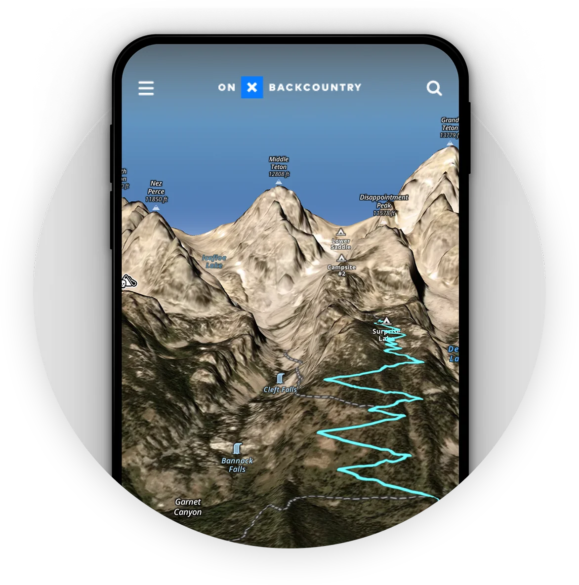
OnX Backcountry is a professional-grade GPS trail map application designed for outdoor enthusiasts who demand reliability and detail in the backcountry. The app supports a wide range of activities including hiking, backpacking, skiing, snowboarding, mountain biking, climbing, and camping. At its core, OnX Backcountry provides access to hundreds of thousands of miles of trails and routes backed by industry-leading map data. Users can visualize routes in immersive 3D terrain before ever leaving home, and carry those maps offline for use in areas with no cell service. LiDAR topo maps and color-coded slope angle shading give adventurers a clear understanding of what terrain they're entering. Real-time weather and conditions data help users make smart go/no-go decisions, while avalanche terrain analysis adds a critical safety layer for winter travelers. The app's land ownership and public/private boundary data — powered by the same database behind onX Hunt — ensures users know exactly where they can legally camp, cross, or explore. Custom waypoints with icons, colors, and personal photos let users annotate their maps meaningfully. Trip tracking and the ability to share trails and markups with other users round out its collaborative features. OnX Backcountry offers a 7-day free trial with full Elite access. Paid tiers include Premium ($29.99/yr) and Elite ($99.99/yr), the latter adding private land boundaries, landowner names, recent imagery, and exclusive gear discounts. It is ideal for serious hikers, backcountry skiers, trail runners, and outdoor guides who need trustworthy navigation.
Key Features
- Offline 3D Terrain & LiDAR Topo Maps: Visualize routes in immersive 3D terrain before heading out and save unlimited offline maps for use in areas without cell service.
- Slope Angle Shading: Color-coded slope angle overlays help users identify steep or hazardous terrain, critical for avalanche safety and route planning.
- Real-Time Weather & Conditions: Live weather data and trail condition reports help adventurers make informed decisions about when to push on or turn back.
- Land Ownership & Access Data: Comprehensive public/private land boundary data lets users know exactly where they can legally hike, camp, or cross.
- Custom Waypoints & Trip Tracking: Mark campsites, water sources, bail-out points, and more with custom icons and images; track trips and share routes with other users.
Use Cases
- Planning a multi-day backpacking trip with detailed topo maps, 3D terrain preview, and offline navigation for remote wilderness areas.
- Backcountry skiers using slope angle shading and avalanche terrain analysis to identify and avoid high-risk zones before a ski tour.
- Mountain bikers discovering and navigating hundreds of thousands of miles of singletrack trails with downloadable offline route maps.
- Hikers and campers using land ownership data to identify legal camping spots and access routes across public and private land.
- Outdoor guides and expedition leaders tracking group trips, marking waypoints, and sharing custom routes with clients or team members.
Pros
- Reliable Offline Maps: Unlimited offline map storage ensures navigation remains functional even in remote areas with no cell signal.
- Comprehensive Terrain Data: LiDAR topo maps, 3D visualization, and slope shading provide a level of terrain detail rarely matched by competing apps.
- Multi-Activity Support: Covers hiking, skiing, snowboarding, mountain biking, climbing, backpacking, and camping in a single app.
- Free Trial Available: A 7-day free trial with full Elite access lets users explore all premium features before committing to a paid plan.
Cons
- Subscription Required for Full Features: Advanced features like private land boundaries, recent imagery, and avalanche terrain analysis require a paid Elite membership.
- Not a General AI Tool: OnX Backcountry is a specialized outdoor navigation app and does not offer AI-generated content, chatbots, or automation features.
- Annual Pricing May Be Steep for Casual Users: At $29.99–$99.99/yr, the cost may be hard to justify for users who only venture outdoors occasionally.
Frequently Asked Questions
Does OnX Backcountry work without cell service?
Yes. Users can download and save unlimited offline maps before their trip, allowing full GPS navigation without any cell or internet connection.
What activities does OnX Backcountry support?
The app supports hiking, backpacking, skiing, snowboarding, mountain biking, rock climbing, and camping, with activity-specific tools and trail data for each.
What is the difference between Premium and Elite memberships?
Premium ($29.99/yr) includes trails, offline maps, 3D terrain, route building, and trail conditions. Elite ($99.99/yr) adds private land boundaries, landowner names, recent satellite imagery, and exclusive outdoor gear discounts.
Is there a free version of OnX Backcountry?
OnX Backcountry offers a 7-day free trial with full Elite membership access, including offline maps, 3D terrain, waypoints, trip tracking, and more. After the trial, a paid subscription is required.
Can I share routes and maps with other users?
Yes. OnX Backcountry lets users share trails, markups, and waypoints with other Backcountry app users, making it easy to collaborate on trip planning.