
O
About
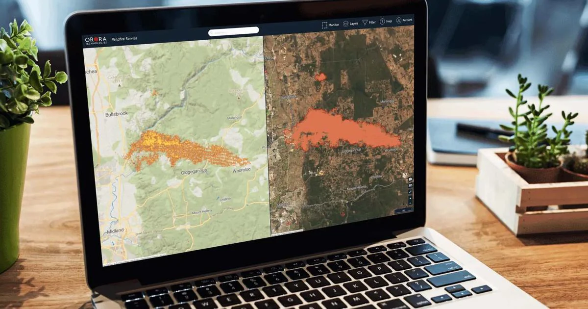
OroraTech provides a comprehensive, space-based wildfire intelligence platform designed to address the growing global threat of wildfires. At its core is the Wildfire Solution — a detection and monitoring system that aggregates thermal and optical data from over 35 satellite and ground-based sources, applying first-in-class detection algorithms to identify hotspots at the earliest possible stage. Beyond detection, OroraTech's Fire Spread product delivers near-real-time predictive modeling of wildfire movement, enabling firefighters and emergency managers to make critical, life-saving decisions with precision. The Burnt Area module uses high-resolution satellite imagery to assess damage severity post-fire, supporting efficient resource allocation and ecosystem recovery planning. The Land Surface Temperature product monitors global thermal anomalies to support climate resilience and environmental decision-making, while the Short-Term Fire Hazard tool (in pilot phase) provides data-driven forecasts for proactive risk planning. OroraTech serves a wide range of industries including civil protection, energy and infrastructure, forestry, and carbon project management. Its API-ready architecture allows seamless integration into existing operational systems, making it a scalable enterprise solution. Whether protecting power lines, managing vast forests, or monitoring carbon credits, OroraTech equips organizations with the reliable, satellite-derived intelligence needed to act before, during, and after wildfire events.
Key Features
- Early Wildfire Detection: Fuses data from 35+ satellite and ground sources with advanced detection algorithms to identify hotspots at the earliest possible stage, minimizing response time.
- Fire Spread Prediction: Delivers near-real-time predictive modeling of wildfire movement and speed, enabling emergency managers and firefighters to make informed, life-saving operational decisions.
- Burnt Area Analysis: Leverages high-resolution satellite imagery to assess fire damage severity globally, helping organizations allocate recovery resources efficiently and plan ecosystem restoration.
- Land Surface Temperature Monitoring: Monitors global thermal anomalies using high-resolution satellite thermal data, supporting climate resilience strategies and proactive environmental decision-making.
- Short-Term Fire Hazard Forecasting: Provides data-driven near-term wildfire risk forecasts to help organizations identify high-risk areas early and support proactive preparedness and operational planning.
Use Cases
- Civil protection agencies and firefighting departments monitoring active wildfire emergencies in near-real-time to coordinate ground response and evacuations.
- Energy utilities and infrastructure operators tracking wildfire proximity to power lines, water pipes, and production facilities to minimize disruption and protect assets.
- Forestry managers and land stewardship organizations receiving early-warning alerts for fire outbreaks across vast, remote forest areas to enable rapid intervention.
- Carbon project operators and environmental organizations monitoring ecosystem integrity and assessing wildfire-related damage to verify carbon credit compliance.
- Climate researchers and government agencies leveraging burnt area severity data and land surface temperature trends to study wildfire impact on ecosystems and inform policy.
Pros
- Unmatched Data Coverage: Aggregates data from 35+ satellite and ground-based sources, providing one of the most comprehensive and reliable wildfire intelligence datasets available globally.
- End-to-End Wildfire Lifecycle Support: Covers the full wildfire management cycle — from early detection and spread prediction to post-fire burnt area analysis and recovery planning — in a single integrated platform.
- Seamless System Integration: API-ready architecture allows organizations to integrate OroraTech's satellite intelligence directly into their existing operational tools and workflows with minimal friction.
- Multi-Industry Applicability: Purpose-built solutions for civil protection, energy and infrastructure, forestry, carbon projects, and climate monitoring make it versatile across sectors facing wildfire risk.
Cons
- Enterprise-Focused Pricing: OroraTech is designed for large organizations and government agencies; pricing is not publicly listed and likely requires a custom enterprise contract, making it inaccessible for small organizations or individuals.
- No Self-Service Free Tier: There is no publicly available free plan or trial — access requires contacting the sales team or requesting a live demo, which can slow onboarding for smaller teams.
- Some Features Still in Pilot: The Short-Term Fire Hazard forecasting product is currently in a pilot phase, meaning it may not yet be available to all customers or fully production-ready.
Frequently Asked Questions
What is OroraTech?
OroraTech is a global wildfire management platform that uses satellite data and AI to deliver early wildfire detection, fire spread prediction, burnt area analysis, and land surface temperature monitoring for organizations in civil protection, forestry, energy, and carbon sectors.
How does OroraTech detect wildfires?
OroraTech fuses thermal and optical data from 35+ satellite and ground-based sources and applies proprietary first-in-class detection algorithms to identify fire hotspots as early as possible, often before fires can spread significantly.
Which industries does OroraTech serve?
OroraTech serves civil protection and emergency response agencies, energy and utility infrastructure operators, forestry and land management organizations, carbon project managers, and climate researchers.
Can OroraTech integrate with existing operational systems?
Yes. OroraTech's platform is designed to integrate seamlessly into existing systems via API, making it compatible with a wide range of operational tools used by emergency services, utilities, and environmental organizations.
How can I try OroraTech?
OroraTech offers a live demo that prospective customers can request through their website. There is no publicly available self-service free trial; access and pricing are arranged directly with the OroraTech team.