

About
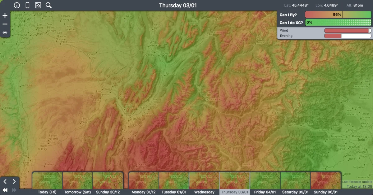
Paraglidable is a specialized AI weather forecasting platform designed exclusively for paragliding pilots. Founded in 2018 by Antoine in France, the tool leverages deep learning to analyze approximately 200 weather parameters per day — including precipitation, cloud cover, wind at multiple altitudes, and humidity — to produce intuitive flying condition scores. At the core of the system is a neural network trained on a decade of weather archives and a database of around 2,000,000 logged paragliding flights. By learning correlations between weather conditions and actual flight reports (including distance, max vario, and max altitude), the model generates two primary forecasts: 'Can I Fly?' (the probability that a flight will be reported given the day's full weather vector) and 'Can I do XC?' (the probability of achieving a cross-country flight of 60+ points using PWC scoring). Pilots can interact with Paraglidable through an interactive web map where they can pin takeoff spots and get color-coded forecasts at a glance. A free API (JSON and XML formats) allows developers and third-party apps to integrate Paraglidable forecasts directly, supporting up to 10 spots per API key. An Android app and mobile-optimized website are also available. The project is fully open-sourced on GitHub, welcoming community contributions. Paraglidable is ideal for recreational paragliders, XC pilots, and developers building aviation weather integrations.
Key Features
- Can I Fly? Score: Probability score estimating whether a flight will be reported given the full weather vector of the day, tailored to local paraglider population density.
- Can I Do XC? Score: Predicts the likelihood of achieving a cross-country flight of 60+ PWC points, helping XC pilots plan ambitious flying days in advance.
- Deep Learning Weather Analysis: A neural network trained on 10 years of weather archives and ~2,000,000 flights analyzes ~200 parameters including wind, precipitation, cloud cover, and humidity at multiple altitudes.
- Free REST API: Developers can integrate Paraglidable forecasts into their own apps or services via a free JSON/XML API, supporting up to 10 spots per API key.
- Interactive Map & Spot Management: An interactive map lets pilots pin their favorite takeoffs and instantly see color-coded flyability scores, with shareable links for each view.
Use Cases
- A recreational paraglider checks the 'Can I Fly?' score each morning to decide whether the weekend trip to a mountain launch is worth making.
- An XC competition pilot uses the 'Can I Do XC?' forecast to identify the best days for long-distance flights and plan training routes accordingly.
- A developer building a paragliding community app integrates the Paraglidable API to display real-time flyability forecasts alongside takeoff spot listings.
- A flying school uses the interactive map to monitor conditions at multiple local launch sites and advise students on lesson scheduling.
- A weather-data researcher or contributor uses the open-source GitHub repository to improve the neural network model with additional regional flight data.
Pros
- Purpose-Built for Paragliding: Unlike generic weather services, Paraglidable's AI is trained specifically on paragliding flight data, making its forecasts uniquely relevant to pilots.
- Free & Open Source: Completely free to use with no paywall, and the source code is publicly available on GitHub for community contributions and self-hosting.
- Developer-Friendly API: A simple, well-documented API in both JSON and XML formats allows easy integration into third-party aviation apps and services at no cost.
- Multi-Platform Access: Available as a web app, mobile-optimized site, and Android app, so pilots can check conditions from any device.
Cons
- Limited to 10 Spots per API Key: The free API restricts users to 10 monitored spots per key, which may be limiting for developers building comprehensive regional tools.
- Server Resource Constraints: As a community-funded, solo-developer project, compute and storage resources are limited, which can affect data freshness or availability of new features.
- No iOS App: Currently only an Android app is available; iOS users must rely on the mobile-optimized website.
Frequently Asked Questions
How does Paraglidable predict flying conditions?
Paraglidable uses a deep learning neural network trained on 10 years of weather archives and approximately 2,000,000 paragliding flights. It analyzes around 200 weather parameters per day — including wind at various altitudes, precipitation, cloud cover, and humidity — and outputs a flyability probability score.
What does the 'Can I Fly?' score mean?
It represents the probability that a flight will be reported at a given location on a given day, based on the full weather vector and the local paraglider population. A high score means conditions are historically favorable for flying.
What does the 'Can I Do XC?' score mean?
This score predicts the probability of achieving a cross-country flight of 60 or more PWC points. It's specifically useful for XC pilots planning longer distance flights.
How do I get an API key?
You can request a free API key directly on the Paraglidable website by entering your email address. The key will be emailed to you and allows access to forecasts for up to 10 spots in JSON or XML format.
Is Paraglidable open source?
Yes, Paraglidable is open-sourced on GitHub. You can view the code, contribute to the project, or self-host your own instance.