

About
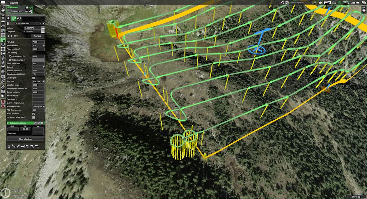
UgCS (developed by SPH Engineering) is a comprehensive drone flight planning and control platform built for professional and enterprise-grade UAV survey operations. It handles the full complexity of missions involving LiDAR scanning, photogrammetry, corridor mapping, vertical scanning, underground utility detection, and environmental monitoring — all from a single, powerful interface. The software's flagship True Terrain Following (TTF) technology automatically adjusts drone altitude to match the underlying terrain, ensuring consistent data quality across rugged or variable landscapes without manual intervention. UgCS is compatible with an extensive range of UAV platforms including DJI M350, DJI M300, FreeFly Alta X, Inspired Flight, Ardupilot-based systems, and other drones on the NDAA-compliant Blue UAS list. It supports integration with professional-grade sensors such as LiDAR units, Ground Penetrating Radars (GPR), magnetometers, gamma-ray spectrometers, echo sounders, and methane detectors — making it a versatile hub for geophysical and environmental data acquisition. Key use cases span a broad set of industries: mining and mineral exploration, construction and engineering surveys, gas pipeline methane inspection, water depth (bathymetry) mapping, unexploded ordnance (UXO) detection, soil mapping, precision agriculture, hydrology, snow and ice studies, and academic research. The platform also integrates with companion tools like GeoHammer for multi-sensor data processing and DroneGIS for online GIS workflows, forming a complete end-to-end survey ecosystem.
Key Features
- True Terrain Following (TTF): Automatically adjusts drone altitude in real time to match ground elevation, ensuring consistent sensor-to-surface distance across complex terrain without manual route adjustments.
- Multi-Sensor Mission Support: Natively supports LiDAR, GPR, magnetometers, gamma-ray spectrometers, methane detectors, echo sounders, and more — enabling diverse geophysical and environmental survey workflows.
- Wide Drone Compatibility: Works with DJI M350, M300, FreeFly, Inspired Flight, Ardupilot-based platforms, and NDAA-compliant Blue UAS drones, giving operators flexibility in hardware choice.
- Corridor & Area Mapping Tools: Provides specialized flight path tools for linear corridor mapping (pipelines, roads, powerlines) and large-area surveys with configurable overlap, altitude, and scan parameters.
- Integrated Ecosystem: Connects with GeoHammer for multi-sensor data post-processing, DroneGIS for online GIS analysis, and UgCS Commander for multi-drone fleet operations.
Use Cases
- Planning and executing LiDAR mapping missions over large or rugged terrain areas for topographic survey and 3D modeling.
- Conducting UAV-based photogrammetry surveys for construction site volumetrics, progress monitoring, and as-built documentation.
- Mapping underground utilities and subsurface features using drone-mounted Ground Penetrating Radar (GPR) payloads.
- Inspecting gas pipelines and energy infrastructure for methane leaks using drone-mounted gas detection sensors.
- Performing mineral exploration and geophysical surveys using magnetometers and gamma-ray spectrometers in remote or difficult-to-access terrain.
Pros
- Unmatched Drone & Sensor Compatibility: Supports a wider range of drone platforms and payloads than most competitors, reducing hardware lock-in for professional survey teams.
- Precision First-Flight Data Collection: True Terrain Following and advanced mission planning tools minimize repeat flights, saving time and operational costs on large-scale surveys.
- Comprehensive Industry Coverage: Handles a broad spectrum of applications from mining and construction to environmental science and UXO detection, making it suitable across many professional verticals.
- End-to-End Survey Workflow: Integrates seamlessly with SPH Engineering's companion tools (GeoHammer, DroneGIS, SkyHub) for a complete planning-to-processing pipeline.
Cons
- Steep Learning Curve: The breadth of features and technical configuration options can be overwhelming for new or casual users without prior UAV survey experience.
- Paid Licensing Model: UgCS is a professional paid software platform, which may be cost-prohibitive for hobbyists or small teams with limited budgets.
- Primarily Desktop-Oriented: The full-featured planning environment is desktop-based, which can limit flexibility for field operators who prefer fully mobile-native workflows.
Frequently Asked Questions
What drones does UgCS support?
UgCS supports a wide range of UAV platforms including DJI M350 RTK, DJI M300 RTK, FreeFly Alta X, Inspired Flight drones, Ardupilot-based systems, and various NDAA-compliant drones from the Blue UAS framework.
What is True Terrain Following (TTF) in UgCS?
True Terrain Following is UgCS's technology that automatically adjusts drone flight altitude based on underlying terrain elevation data, maintaining a constant height above ground. This is critical for LiDAR scanning and GPR surveys that require consistent sensor-to-surface distance.
Is UgCS NDAA-compliant?
Yes, UgCS supports drones from the Blue UAS list, which are NDAA-compliant platforms approved for use by U.S. government agencies and contractors requiring domestically manufactured or vetted drone hardware.
What types of surveys can UgCS plan?
UgCS supports LiDAR mapping, photogrammetry, corridor mapping, vertical scanning, underground utility detection (GPR), gas pipeline methane inspection, bathymetry (water depth mapping), mineral exploration, soil mapping, UXO detection, and more.
Does UgCS integrate with data processing tools?
Yes. UgCS integrates with SPH Engineering's GeoHammer for multi-sensor geophysical data processing and DroneGIS for online GIS-based analysis, forming a complete survey-to-analysis workflow.