

About
Urban Sky fills a critical gap between low-flying drones and expensive satellites by pioneering routine access to the stratosphere—the 40,000–75,000 ft altitude band that avoids weather, airspace congestion, and the high costs of orbital systems. Its flagship Microballoon platform, protected by 20+ patents, can be launched in under five minutes and remain aloft for days or months, carrying a multi-axis pointing payload with RGB, VNIR, and LWIR sensor options and real-time data downlink. For defense and intelligence customers, the platform enables tactical ISR, communications relay, and persistent surveillance in contested environments—deployable on demand and recoverable for reuse. Commercial clients gain high-resolution imagery and sensing for infrastructure monitoring, precision agriculture, and mapping, combining satellite-level coverage with aircraft-grade resolution at significantly lower cost. Scientists and weather researchers benefit from affordable, repeatable near-space access for atmospheric studies and climate monitoring. Urban Sky's integrated software stack handles mission planning, flight control, and data processing, converting raw sensor feeds into actionable intelligence. The company has received a $99M U.S. Air Force award and $30M in additional funding, and has been featured in TechCrunch, CNN, Popular Science, and MIT Technology Review. Based in Denver, CO, it is positioned as the premier platform for organizations that need persistent, flexible, high-altitude sensing without the cost or lead times of traditional space assets.
Key Features
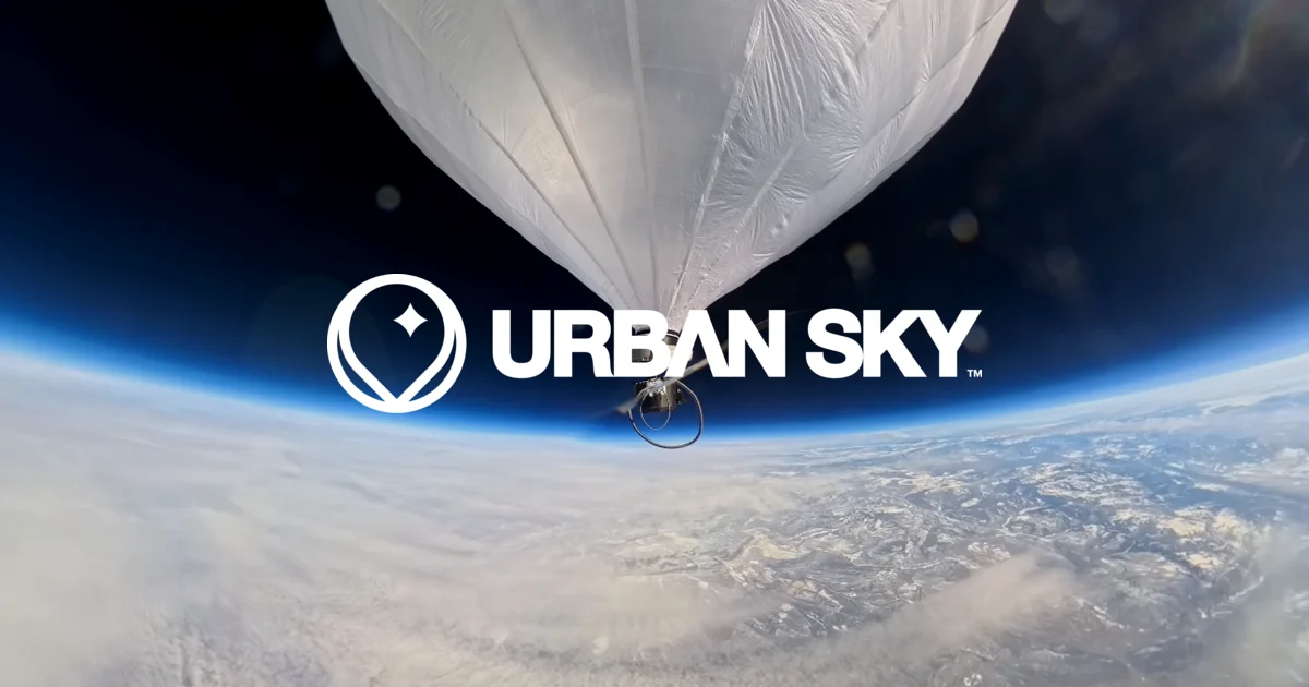
- Rapid Microballoon Deployment: Launch the world's first precisely placeable stratospheric balloon in under 5 minutes to altitudes of 40,000–75,000 feet, with endurance from days to months.
- Multi-Sensor Payload: Multi-axis pointing platform supporting RGB, VNIR, and LWIR sensors with real-time data downlink from 75,000 feet for comprehensive aerial intelligence.
- Integrated Mission Software: End-to-end software stack for mission planning, flight control, and data processing—turning raw sensor data into actionable intelligence.
- Recoverable & Reusable Platform: Unlike satellites or expendable drones, the Microballoon is recoverable and ready for the next mission, dramatically reducing per-mission costs.
- Tri-Market Versatility: A single platform serves defense ISR, commercial remote sensing, and scientific atmospheric research, enabling diverse mission profiles without additional hardware.
Use Cases
- Persistent tactical ISR and surveillance in contested or denied airspace for defense and intelligence operations
- Real-time high-resolution imagery for infrastructure inspection, precision agriculture, and geospatial mapping
- Communications relay platform providing connectivity in remote or disaster-affected regions
- Atmospheric and climate research with affordable, repeatable near-space access for scientific institutions
- Wildfire tracking and environmental monitoring using persistent thermal and multispectral sensors
Pros
- Far Lower Cost Than Satellites: Delivers satellite-grade persistence and coverage at a fraction of the launch and operational cost, making high-altitude sensing accessible to more organizations.
- On-Demand, Sub-5-Minute Launch: Unmatched deployment speed compared to aircraft logistics or months-long satellite scheduling, critical for time-sensitive defense and emergency scenarios.
- Higher Resolution Than Orbit: Operating at 40,000–75,000 ft yields significantly higher image resolution and lower latency than low-Earth-orbit satellites.
- Proven Defense Backing: A $99M U.S. Air Force award validates operational readiness and reliability for the most demanding customers.
Cons
- Enterprise/Government Market Focus: Pricing and procurement are tailored to defense and large commercial contracts, making the platform inaccessible for small organizations or individual researchers.
- Weather Dependency at Launch: While the stratosphere itself is stable, ground-level launch conditions and recovery operations can still be affected by adverse local weather.
- Limited Public Pricing Transparency: No self-serve or published pricing is available; access requires direct sales engagement, which can slow procurement timelines.
Frequently Asked Questions
What altitude does the Urban Sky Microballoon reach?
The Microballoon operates in the 40,000–75,000 foot range (the stratosphere), above commercial air traffic and weather systems but far below orbital altitudes.
How long can the Microballoon stay aloft?
Depending on mission configuration, the platform can remain aloft for days to months, providing persistent coverage unmatched by fixed-wing aircraft or drones.
What sensors does the platform support?
The multi-axis pointing payload supports RGB (visible), VNIR (near-infrared), and LWIR (thermal) sensors, with real-time data downlink to ground stations.
Who are the primary customers?
Urban Sky serves three markets: defense and intelligence agencies needing tactical ISR and surveillance, commercial clients requiring high-resolution earth observation, and scientific institutions conducting atmospheric and climate research.
How does Urban Sky compare to satellites and drones?
The Microballoon bridges the gap: it deploys in minutes (vs. months for satellites), operates for days (vs. hours for aircraft/drones), covers large areas (vs. limited drone range), and costs a fraction of orbital systems—combining the persistence of satellites with the flexibility of aircraft.