

About
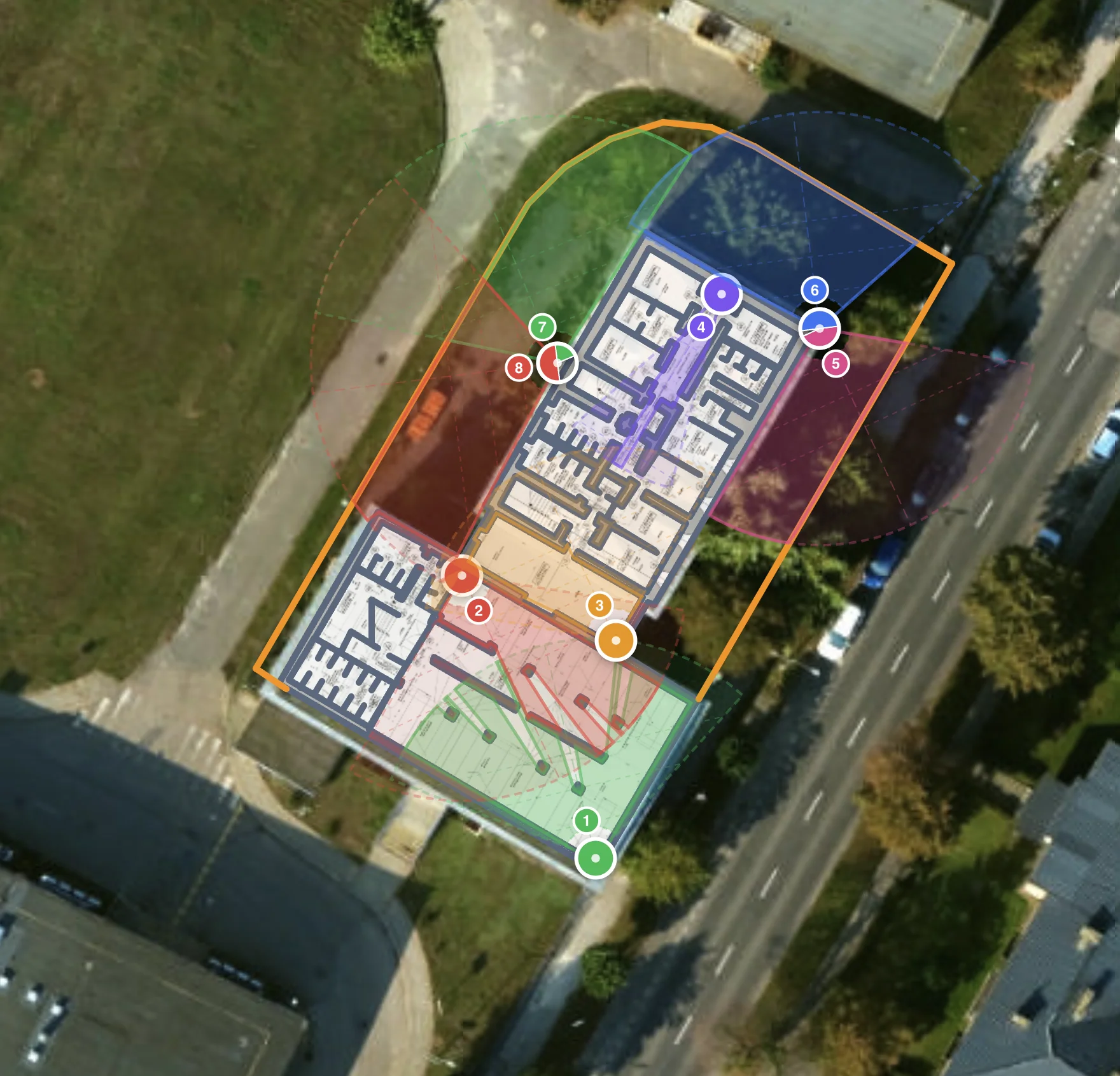
CCTVplanner is a purpose-built, browser-based platform for designing and documenting professional CCTV surveillance systems. Security installers, system integrators, consultants, and architects can create complete camera layouts directly on satellite maps without any software installation or CAD training. The tool includes a database of over 23,000 real camera models featuring accurate sensor sizes, focal lengths, and resolution specifications, enabling precise field-of-view (FOV) calculations. Users drag and drop cameras onto the map, rotate and adjust direction, and instantly see coverage visualized in real time. Building outlines, rooms, fences, and zones can be drawn directly on the map for both indoor and outdoor planning scenarios. An integrated coverage analysis engine highlights surveillance gaps and helps optimize camera count and placement before any physical installation occurs. When the design is finalized, users generate professional PDF reports — complete with camera layouts, equipment lists, and coverage maps — ready for client proposals or installation crews. Unlike generic tools such as Visio or AutoCAD, CCTVplanner is purpose-built for surveillance design, removing the need for specialized CAD skills while delivering professional-grade outputs. The free plan supports up to 2 saved projects, while paid plans unlock unlimited projects and advanced features. Trusted by 2,000+ installers and integrators across 100+ countries, CCTVplanner accelerates site surveys, standardizes proposals, and helps security professionals deliver clear, data-backed visual assessments to their clients.
Key Features
- Real-Time FOV Visualization: See exactly what each camera covers as you design. Adjust lens, angle, and range on-the-fly to eliminate blind spots before a single hole is drilled.
- 23,000+ Camera Model Database: Choose from real-world camera models with accurate sensor sizes, focal lengths, and resolution specs to ensure precise field-of-view calculations.
- Drag & Drop on Satellite Maps: Navigate to any address worldwide, drop cameras on the satellite map, and reposition or rotate them with intuitive drag-and-drop controls.
- Coverage Gap Analysis: Instantly identify uncovered areas and optimize camera count and positioning for full-site coverage before committing to an installation plan.
- Professional PDF Export: Generate client-ready PDF reports with complete camera layouts, equipment bills of materials, and coverage maps suitable for proposals and installation documentation.
Use Cases
- CCTV installers conducting pre-installation site surveys to show clients exact camera placement before drilling or mounting any equipment.
- System integrators designing multi-site surveillance systems with standardized layouts and professional proposal documentation.
- Security consultants delivering visual gap analysis reports that identify uncovered areas and recommend optimal camera positioning.
- Architects and building designers integrating surveillance planning into blueprints early to ensure camera positions align with floor plans and aesthetics.
- Security managers evaluating camera coverage for warehouses, retail spaces, or office buildings to justify equipment budgets and demonstrate ROI.
Pros
- No Installation Required: Runs entirely in the browser — no downloads, plugins, or CAD experience needed, making it accessible on any device from any location.
- Massive, Accurate Camera Database: With 23,000+ real camera models and verified specs, FOV calculations reflect how cameras actually perform rather than relying on estimates.
- Free Tier Available: The full design tool is accessible at no cost, allowing professionals to evaluate the platform and complete small projects without any upfront commitment.
- Purpose-Built for Surveillance: Unlike generic diagramming tools, every feature — coverage analysis, FOV rendering, PDF export format — is tailored specifically for CCTV planning workflows.
Cons
- Free Plan Limited to 2 Projects: Users on the free tier can only save up to 2 designs, which may be restrictive for installers managing multiple active projects simultaneously.
- Niche Application Scope: CCTVplanner is exclusively focused on surveillance system design, making it unsuitable as a general-purpose diagramming or floor-plan tool.
- Web-Only Platform: With no native desktop or mobile app, offline access is not supported, which can be limiting during on-site surveys in areas with poor connectivity.
Frequently Asked Questions
Is CCTVplanner really free to use?
Yes. You can create CCTV designs, place cameras, visualize field of view, and export layouts at no cost. A free account gives you access to the full design tool with up to 2 saved projects. Paid plans unlock unlimited projects and advanced features.
Do I need to install any software to use CCTVplanner?
No installation is required. CCTVplanner runs entirely in your browser and works on any device — desktop, laptop, or tablet — without downloading any software or plugins.
What makes CCTVplanner better than Visio or AutoCAD for CCTV design?
CCTVplanner is purpose-built for surveillance design. Unlike generic drawing tools, it includes real-time field-of-view visualization, automatic coverage analysis, a camera database with accurate specs, and one-click PDF export formatted for client proposals — all without requiring CAD experience.
How accurate are the camera field-of-view calculations?
FOV calculations are based on real-world specifications pulled from a database of 23,000+ actual camera models, including sensor sizes, focal lengths, and resolution data, ensuring the visualizations closely reflect real-world performance.
Can CCTVplanner be used for large multi-site security projects?
Yes. System integrators use CCTVplanner to design multi-site security systems with consistent layouts. Paid plans support unlimited projects, making it practical for managing multiple client sites and standardizing proposal documentation at scale.