

About
DJI Terra is a professional 3D reconstruction and mapping software platform built to work in tight integration with DJI's enterprise drone ecosystem. It leverages next-generation AI reconstruction technologies—including 3D Gaussian Splatting (3DGS), photogrammetry-based mesh generation, and LiDAR point cloud processing—to convert raw aerial data into high-fidelity digital assets. Users can generate accurate 2D orthomosaics, detailed 3D models, and immersive photorealistic scenes from visible light imagery captured by DJI cameras. The software also supports multispectral reconstruction for precision agriculture, enabling NDVI mapping and crop health analysis. For large-scale projects, Cluster Reconstruction distributes computation across multiple machines to dramatically reduce processing times. When paired with DJI drones like the Matrice 350 RTK, Zenmuse P1, and Zenmuse L2 LiDAR sensor, Terra provides a unified hardware-software workflow covering flight planning, data capture, processing, and deliverable export. It is widely used across industries including land surveying, cadastral mapping, construction progress management, BIM, mining, infrastructure inspection, heritage preservation, and disaster response. A free trial is available, with full licenses offered for commercial and enterprise use.
Key Features
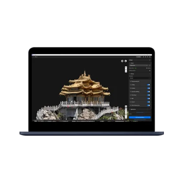
- 3D Gaussian Splatting (3DGS): Generates photorealistic, immersive 3D scenes from drone imagery using the latest neural reconstruction technology for visually stunning digital twin outputs.
- Photogrammetry & 3D Mesh Reconstruction: Produces accurate 2D orthomosaics and 3D mesh models from visible light imagery with survey-grade precision, suitable for BIM, mapping, and inspection workflows.
- LiDAR Point Cloud Processing: Processes data from DJI LiDAR payloads (e.g., Zenmuse L2) to generate dense, highly accurate point clouds for terrain modeling, volumetric analysis, and infrastructure inspection.
- Multispectral Reconstruction: Supports multispectral imagery processing for precision agriculture use cases, enabling NDVI and vegetation index mapping to assess crop health and forest coverage.
- Cluster Reconstruction: Distributes large-scale reconstruction tasks across multiple computers to dramatically reduce processing time for projects covering hundreds or thousands of images.
Use Cases
- Land surveyors using DJI drones to generate accurate orthomosaics and 3D terrain models for cadastral and topographic mapping projects.
- Construction project managers monitoring earthwork progress, comparing site scans over time, and integrating outputs into BIM workflows.
- Precision agriculture professionals processing multispectral drone imagery to assess crop health, identify stress zones, and optimize field management.
- Infrastructure inspection teams processing aerial imagery of bridges, power lines, and facades to generate detailed 3D models for structural analysis.
- Heritage preservation specialists creating photorealistic 3D digital twins of historical sites and monuments using Gaussian Splatting for archival and public engagement purposes.
Pros
- Seamless DJI Ecosystem Integration: Designed to work natively with DJI drones, cameras, and LiDAR payloads, providing a unified end-to-end workflow from flight planning to final deliverables without third-party compatibility issues.
- Next-Generation Reconstruction Technologies: Supports both traditional photogrammetry and cutting-edge 3D Gaussian Splatting, giving professionals access to the latest AI-driven reconstruction methods in one platform.
- Broad Industry Applicability: Covers a wide range of use cases including surveying, construction, agriculture, mining, and emergency response, making it versatile across enterprise sectors.
- Free Trial Available: Users can apply for a trial activation code to evaluate the software before committing to a commercial license, lowering the barrier to adoption.
Cons
- DJI Hardware Dependency: Full functionality is optimized for DJI drones and payloads; users with non-DJI equipment may experience limited compatibility or reduced feature availability.
- Enterprise Pricing: As a professional enterprise product, DJI Terra carries a significant cost that may be prohibitive for individual users, small businesses, or hobbyists.
- Windows-Only Desktop App: DJI Terra is a desktop application primarily for Windows, which limits accessibility for users on macOS, Linux, or those who prefer cloud-based processing platforms.
Frequently Asked Questions
What is DJI Terra used for?
DJI Terra is used for processing aerial imagery and LiDAR data collected by DJI drones to produce 2D orthomosaics, 3D models, point clouds, and photorealistic Gaussian Splat scenes for applications like land surveying, construction management, agriculture, and infrastructure inspection.
What is 3D Gaussian Splatting in DJI Terra?
3D Gaussian Splatting (3DGS) is a next-generation neural reconstruction method that creates photorealistic, immersive 3D representations of real-world environments from drone imagery. DJI Terra uses this technology to produce higher-quality visual outputs compared to traditional mesh-based photogrammetry.
Does DJI Terra work with non-DJI drones?
DJI Terra is primarily designed and optimized for use with DJI drones and payloads. While it may support imagery from other sources in some reconstruction modes, the full feature set—including integrated flight planning and LiDAR processing—is tailored for the DJI hardware ecosystem.
Is there a free trial for DJI Terra?
Yes. Users can apply for a free trial by filling out a form on the DJI Terra product page. After system review, an activation code is sent by email. If you previously applied for a trial before version 5.0.0, you can apply again to experience newer features like Gaussian Splatting.
What types of data can DJI Terra process?
DJI Terra can process visible light imagery for 2D/3D photogrammetric reconstruction, multispectral imagery for agricultural analysis, and LiDAR point cloud data from DJI LiDAR payloads such as the Zenmuse L2. It supports reconstruction from over 500 photos in a single project.