

About
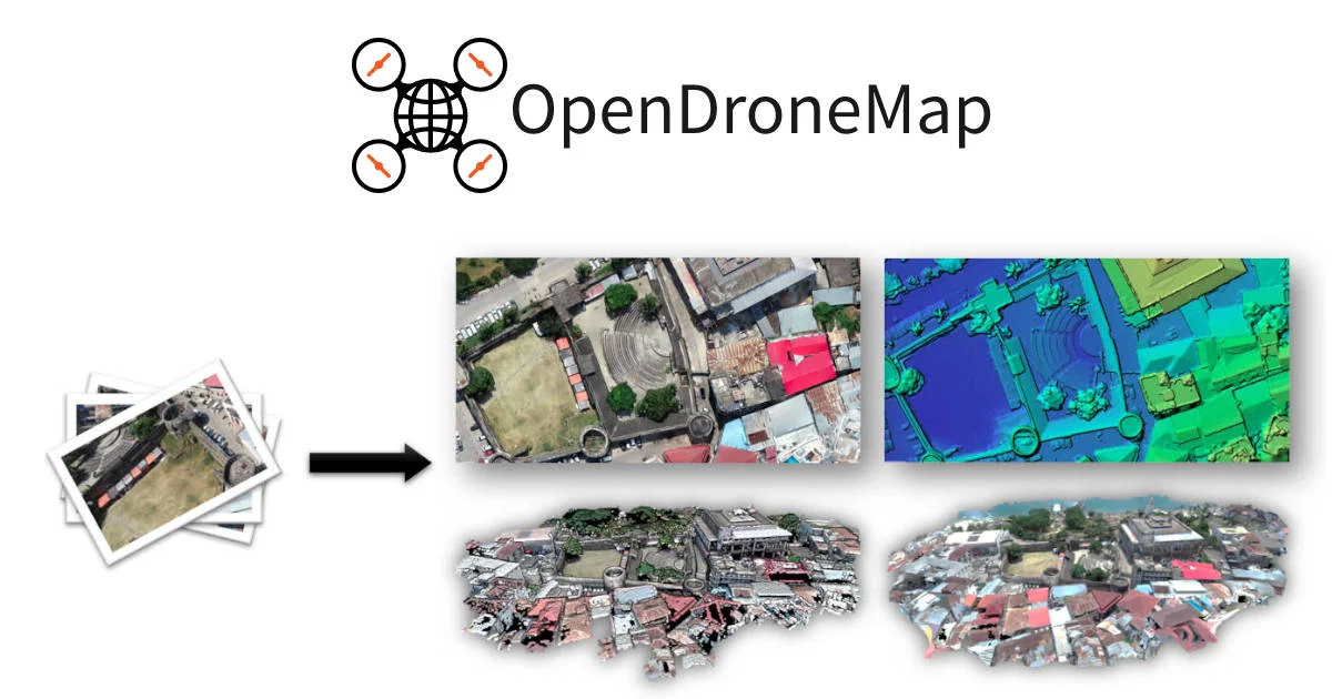
OpenDroneMap (ODM) is a powerful, community-driven open source platform for transforming drone, balloon, or kite imagery into actionable geospatial data. At its core, ODM is a command-line toolkit capable of producing orthomosaic maps, dense point clouds, textured 3D models, and Digital Elevation Models (DEMs) from raw aerial photos—regardless of camera type or image orientation. The project encompasses a rich ecosystem of tools: NodeODM provides a lightweight REST API and minimal web interface for programmatic access; CloudODM enables cloud-based aerial image processing from the command line; PyODM is a Python SDK for embedding aerial processing into custom applications; and ClusterODM serves as a load-balancing reverse proxy for horizontal scaling of large processing workloads. Additional tools like FIELDimageR (agricultural orthomosaic analysis) and Find-GCP (ArUco marker detection) extend the platform to specialized domains. Built on a foundation of proven open source libraries—including OpenSfM, OpenMVS, PDAL, GDAL, and GRASS GIS—OpenDroneMap delivers professional-grade photogrammetry results at zero licensing cost. It is ideal for surveyors, GIS professionals, agricultural researchers, environmental scientists, and developers building geospatial applications. With an active community forum, extensive documentation, and a growing contributor base, OpenDroneMap is the go-to solution for anyone needing accessible, scalable, and reproducible aerial mapping workflows.
Key Features
- Aerial Image Processing: Convert drone, balloon, or kite images into orthomosaic maps, dense point clouds, textured 3D models, and Digital Elevation Models (DEMs) using industry-standard photogrammetry pipelines.
- REST API via NodeODM: NodeODM exposes a lightweight REST API and minimal web UI, allowing developers to integrate aerial image processing into their own applications and workflows programmatically.
- Python SDK (PyODM): PyODM provides a Python interface to ODM processing, enabling data scientists and developers to automate and embed aerial mapping capabilities directly into their Python applications.
- Cloud & Scalable Processing: CloudODM enables processing of large aerial datasets in the cloud, while ClusterODM provides load balancing and horizontal scaling for high-volume or enterprise-grade mapping tasks.
- Agricultural & Specialized Analysis: FIELDimageR extends ODM's capabilities with an R package for analyzing orthomosaic images from agricultural field trials, supporting precision agriculture workflows.
Use Cases
- Agricultural field monitoring and precision agriculture analysis using orthomosaic imagery and the FIELDimageR R package
- Topographic surveying and generation of Digital Elevation Models (DEMs) for civil engineering and land planning projects
- Environmental monitoring and change detection through repeated aerial mapping of forests, wetlands, or coastlines
- Construction site progress tracking by creating georeferenced 3D models and maps at regular intervals
- Building custom geospatial applications that embed automated drone image processing via the PyODM Python SDK or NodeODM REST API
Pros
- Completely Free and Open Source: OpenDroneMap carries no licensing fees and is freely available on GitHub, making professional-grade photogrammetry accessible to individuals, researchers, and organizations of all sizes.
- Comprehensive Ecosystem: A rich suite of tools — CLI, REST API, Python SDK, cloud client, and load balancer — covers every use case from local experimentation to large-scale enterprise deployments.
- Industry-Proven Standard: Since 2014, ODM has established itself as the de-facto open source standard for drone image processing, backed by a vibrant community and extensive documentation.
- Supports Any Camera or Orientation: ODM is camera-agnostic and handles images from virtually any drone or aerial platform regardless of capture orientation, making it highly versatile.
Cons
- Steep Learning Curve for Beginners: The primary ODM interface is a command-line toolkit, which can be intimidating for non-technical users without familiarity with terminal environments or GIS concepts.
- High Computational Requirements: Processing large aerial datasets demands significant CPU, RAM, and storage resources, which may require cloud infrastructure or high-end hardware for professional-scale projects.
- Limited Built-in GUI: While NodeODM offers a minimal web interface, a full graphical experience requires third-party frontends like WebODM, adding setup complexity.
Frequently Asked Questions
What is OpenDroneMap?
OpenDroneMap (ODM) is a free, open source ecosystem of tools for processing aerial images captured by drones, balloons, or kites into maps, point clouds, 3D models, and Digital Elevation Models (DEMs).
Is OpenDroneMap really free to use?
Yes. OpenDroneMap is fully open source and available at no cost under an open license. The source code is hosted on GitHub and the community forum is free to join.
What types of outputs can OpenDroneMap generate?
ODM can produce orthomosaic maps, dense 3D point clouds, textured 3D mesh models, and Digital Elevation Models (DEMs) — all from overlapping aerial photos.
What is the difference between ODM, NodeODM, and CloudODM?
ODM is the core command-line processing engine. NodeODM wraps it with a REST API and lightweight web interface for programmatic access. CloudODM is a command-line client that sends processing jobs to cloud-hosted NodeODM instances.
Can OpenDroneMap scale to large datasets?
Yes. ClusterODM acts as a load-balancing reverse proxy compatible with the NodeODM API, enabling horizontal scaling across multiple processing nodes for handling large or time-sensitive aerial mapping workloads.